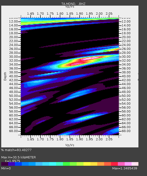
MDND Maddock, ND, USA - Earthquake Result Viewer
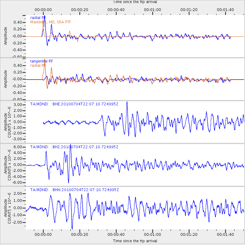
Earthquake location: Near East Coast Of Honshu, Japan
Earthquake latitude/longitude: 39.7/142.4
Earthquake time(UTC): 2010/07/04 (185) 21:55:51 GMT
Earthquake Depth: 27 km
Earthquake Magnitude: 6.4 MB, 6.1 MS, 6.3 MW, 6.2 MW
Earthquake Catalog/Contributor: WHDF/NEIC
Network: TA USArray Transportable Network (new EarthScope stations)
Station: MDND Maddock, ND, USA
Lat/Lon: 47.85 N/99.60 W
Elevation: 479 m
Distance: 76.9 deg
Az: 37.616 deg
Baz: 315.642 deg
Ray Param: 0.050625328
Estimated Moho Depth: 30.5 km
Estimated Crust Vp/Vs: 1.96
Assumed Crust Vp: 6.53 km/s
Estimated Crust Vs: 3.336 km/s
Estimated Crust Poisson's Ratio: 0.32
Radial Match: 93.48277 %
Radial Bump: 400
Transverse Match: 87.84029 %
Transverse Bump: 400
SOD ConfigId: 319893
Insert Time: 2011-01-05 00:14:35.480 +0000
GWidth: 2.5
Max Bumps: 400
Tol: 0.001

Signal To Noise

ChannelStoNSTALTA
TA:MDND: :BHZ:20100704T22:07:10.724995Z21.4774822.019472E-69.402741E-8
TA:MDND: :BHN:20100704T22:07:10.724995Z4.4758638.214557E-71.8353015E-7
TA:MDND: :BHE:20100704T22:07:10.724995Z5.4692959.158403E-71.6745126E-7
Arrivals
Ps4.6 SECOND
PpPs13 SECOND
PsPs/PpSs18 SECOND