You are here: Home > Network List > TA - USArray Transportable Network (new EarthScope stations) Stations List
> Station E22A Miles City, MT, USA > Earthquake Result Viewer
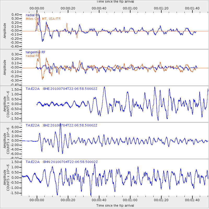
E22A Miles City, MT, USA - Earthquake Result Viewer
*The percent match for this event was below the threshold and hence no stack was calculated.
| Earthquake location: |
Near East Coast Of Honshu, Japan |
| Earthquake latitude/longitude: |
39.7/142.4 |
| Earthquake time(UTC): |
2010/07/04 (185) 21:55:51 GMT |
| Earthquake Depth: |
27 km |
| Earthquake Magnitude: |
6.4 MB, 6.1 MS, 6.3 MW, 6.2 MW |
| Earthquake Catalog/Contributor: |
WHDF/NEIC |
|
| Network: |
TA USArray Transportable Network (new EarthScope stations) |
| Station: |
E22A Miles City, MT, USA |
| Lat/Lon: |
46.44 N/105.95 W |
| Elevation: |
784 m |
|
| Distance: |
74.8 deg |
| Az: |
41.756 deg |
| Baz: |
312.014 deg |
| Ray Param: |
$rayparam |
*The percent match for this event was below the threshold and hence was not used in the summary stack. |
|
| Radial Match: |
89.65721 % |
| Radial Bump: |
400 |
| Transverse Match: |
83.84128 % |
| Transverse Bump: |
400 |
| SOD ConfigId: |
319893 |
| Insert Time: |
2011-01-05 00:15:38.571 +0000 |
| GWidth: |
2.5 |
| Max Bumps: |
400 |
| Tol: |
0.001 |
|
Signal To Noise
| Channel | StoN | STA | LTA |
| TA:E22A: :BHZ:20100704T22:06:58.50002Z | 19.899305 | 2.039026E-6 | 1.0246719E-7 |
| TA:E22A: :BHN:20100704T22:06:58.50002Z | 1.9208114 | 3.466251E-7 | 1.8045763E-7 |
| TA:E22A: :BHE:20100704T22:06:58.50002Z | 2.3398323 | 3.3861184E-7 | 1.4471628E-7 |
| Arrivals |
| Ps | |
| PpPs | |
| PsPs/PpSs | |


