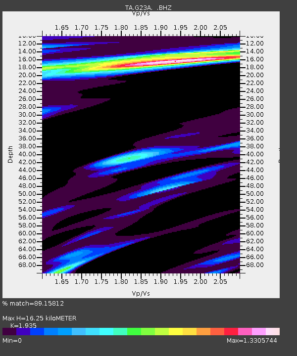
G23A Biddle, MT, USA - Earthquake Result Viewer
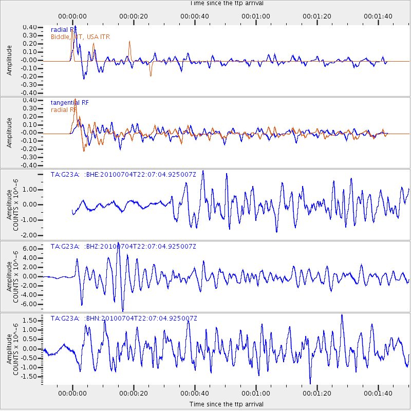
Earthquake location: Near East Coast Of Honshu, Japan
Earthquake latitude/longitude: 39.7/142.4
Earthquake time(UTC): 2010/07/04 (185) 21:55:51 GMT
Earthquake Depth: 27 km
Earthquake Magnitude: 6.4 MB, 6.1 MS, 6.3 MW, 6.2 MW
Earthquake Catalog/Contributor: WHDF/NEIC
Network: TA USArray Transportable Network (new EarthScope stations)
Station: G23A Biddle, MT, USA
Lat/Lon: 45.20 N/105.39 W
Elevation: 1064 m
Distance: 75.9 deg
Az: 42.431 deg
Baz: 312.583 deg
Ray Param: 0.051316563
Estimated Moho Depth: 16.25 km
Estimated Crust Vp/Vs: 1.93
Assumed Crust Vp: 6.242 km/s
Estimated Crust Vs: 3.226 km/s
Estimated Crust Poisson's Ratio: 0.32
Radial Match: 89.15812 %
Radial Bump: 400
Transverse Match: 78.23674 %
Transverse Bump: 400
SOD ConfigId: 319893
Insert Time: 2011-01-05 00:17:06.807 +0000
GWidth: 2.5
Max Bumps: 400
Tol: 0.001

Signal To Noise

ChannelStoNSTALTA
TA:G23A: :BHZ:20100704T22:07:04.925007Z19.5843092.4163605E-61.2338248E-7
TA:G23A: :BHN:20100704T22:07:04.925007Z2.34691956.549256E-72.7905753E-7
TA:G23A: :BHE:20100704T22:07:04.925007Z2.1621614.759564E-72.2012993E-7
Arrivals
Ps2.5 SECOND
PpPs7.4 SECOND
PsPs/PpSs9.9 SECOND