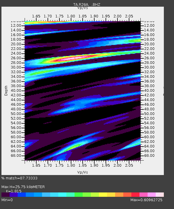
R26A Arlington, CO, USA - Earthquake Result Viewer

Earthquake location: Near East Coast Of Honshu, Japan
Earthquake latitude/longitude: 39.7/142.4
Earthquake time(UTC): 2010/07/04 (185) 21:55:51 GMT
Earthquake Depth: 27 km
Earthquake Magnitude: 6.4 MB, 6.1 MS, 6.3 MW, 6.2 MW
Earthquake Catalog/Contributor: WHDF/NEIC
Network: TA USArray Transportable Network (new EarthScope stations)
Station: R26A Arlington, CO, USA
Lat/Lon: 38.30 N/103.45 W
Elevation: 1304 m
Distance: 81.7 deg
Az: 46.493 deg
Baz: 314.665 deg
Ray Param: 0.047354963
Estimated Moho Depth: 25.75 km
Estimated Crust Vp/Vs: 1.82
Assumed Crust Vp: 6.242 km/s
Estimated Crust Vs: 3.439 km/s
Estimated Crust Poisson's Ratio: 0.28
Radial Match: 87.73333 %
Radial Bump: 350
Transverse Match: 68.49063 %
Transverse Bump: 400
SOD ConfigId: 319893
Insert Time: 2011-01-05 00:17:18.974 +0000
GWidth: 2.5
Max Bumps: 400
Tol: 0.001

Signal To Noise

ChannelStoNSTALTA
TA:R26A: :BHZ:20100704T22:07:36.724995Z6.7631551.2467073E-61.8433812E-7
TA:R26A: :BHN:20100704T22:07:36.724995Z3.07187253.670384E-71.194836E-7
TA:R26A: :BHE:20100704T22:07:36.724995Z2.77612383.288647E-71.1846183E-7
Arrivals
Ps3.4 SECOND
PpPs11 SECOND
PsPs/PpSs15 SECOND