You are here: Home > Network List > TA - USArray Transportable Network (new EarthScope stations) Stations List
> Station P26A Davis Ranch, Arriba, CO, USA > Earthquake Result Viewer
P26A Davis Ranch, Arriba, CO, USA - Earthquake Result Viewer

| Earthquake location: |
Near East Coast Of Honshu, Japan |
| Earthquake latitude/longitude: |
39.7/142.4 |
| Earthquake time(UTC): |
2010/07/04 (185) 21:55:51 GMT |
| Earthquake Depth: |
27 km |
| Earthquake Magnitude: |
6.4 MB, 6.1 MS, 6.3 MW, 6.2 MW |
| Earthquake Catalog/Contributor: |
WHDF/NEIC |
|
| Network: |
TA USArray Transportable Network (new EarthScope stations) |
| Station: |
P26A Davis Ranch, Arriba, CO, USA |
| Lat/Lon: |
39.56 N/103.35 W |
| Elevation: |
1566 m |
|
| Distance: |
80.9 deg |
| Az: |
45.532 deg |
| Baz: |
314.582 deg |
| Ray Param: |
0.047935687 |
| Estimated Moho Depth: |
18.0 km |
| Estimated Crust Vp/Vs: |
1.70 |
| Assumed Crust Vp: |
6.242 km/s |
| Estimated Crust Vs: |
3.672 km/s |
| Estimated Crust Poisson's Ratio: |
0.24 |
|
| Radial Match: |
86.121216 % |
| Radial Bump: |
387 |
| Transverse Match: |
81.390594 % |
| Transverse Bump: |
349 |
| SOD ConfigId: |
319893 |
| Insert Time: |
2011-01-05 00:17:30.446 +0000 |
| GWidth: |
2.5 |
| Max Bumps: |
400 |
| Tol: |
0.001 |
|
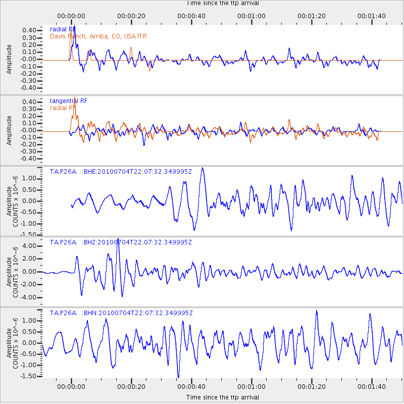
Signal To Noise
| Channel | StoN | STA | LTA |
| TA:P26A: :BHZ:20100704T22:07:32.349995Z | 15.2467575 | 1.4933062E-6 | 9.794254E-8 |
| TA:P26A: :BHN:20100704T22:07:32.349995Z | 1.8111032 | 3.5753598E-7 | 1.9741336E-7 |
| TA:P26A: :BHE:20100704T22:07:32.349995Z | 1.98853 | 3.928006E-7 | 1.9753314E-7 |
| Arrivals |
| Ps | 2.1 SECOND |
| PpPs | 7.6 SECOND |
| PsPs/PpSs | 9.7 SECOND |


