You are here: Home > Network List > IU - Global Seismograph Network (GSN - IRIS/USGS) Stations List
> Station CTAO Charters Towers, Australia > Earthquake Result Viewer
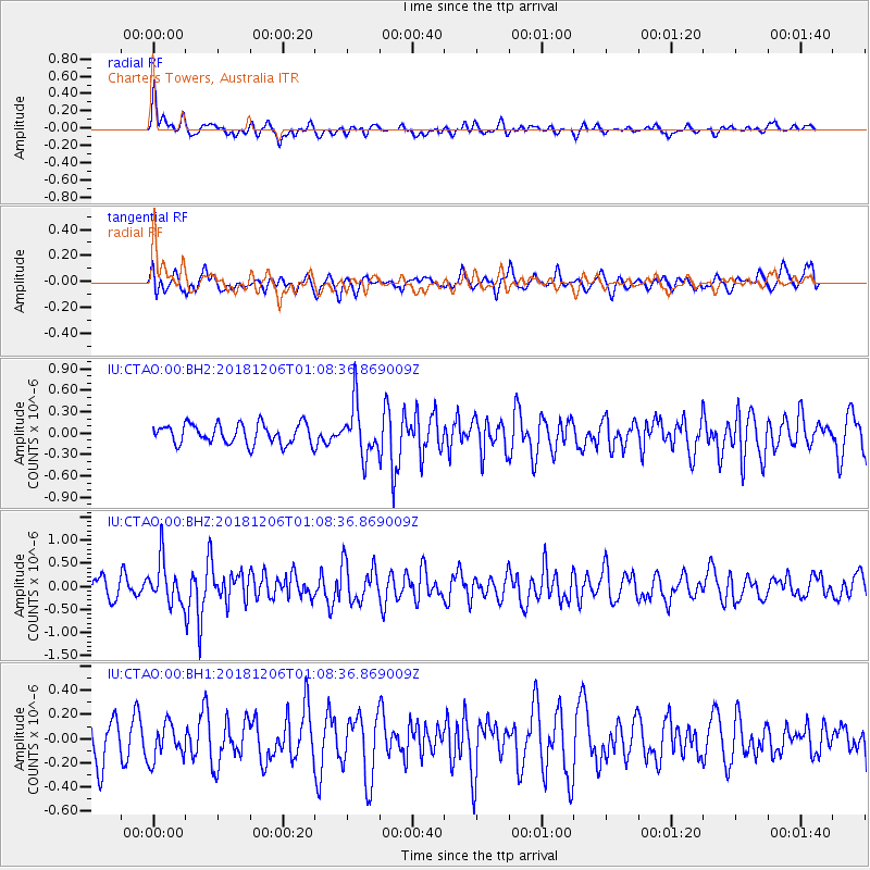
CTAO Charters Towers, Australia - Earthquake Result Viewer
*The percent match for this event was below the threshold and hence no stack was calculated.
| Earthquake location: |
Sumbawa Region, Indonesia |
| Earthquake latitude/longitude: |
-8.4/116.0 |
| Earthquake time(UTC): |
2018/12/06 (340) 01:02:46 GMT |
| Earthquake Depth: |
12 km |
| Earthquake Magnitude: |
5.5 Mww |
| Earthquake Catalog/Contributor: |
NEIC PDE/us |
|
| Network: |
IU Global Seismograph Network (GSN - IRIS/USGS) |
| Station: |
CTAO Charters Towers, Australia |
| Lat/Lon: |
20.09 S/146.25 E |
| Elevation: |
357 m |
|
| Distance: |
31.5 deg |
| Az: |
114.962 deg |
| Baz: |
287.373 deg |
| Ray Param: |
$rayparam |
*The percent match for this event was below the threshold and hence was not used in the summary stack. |
|
| Radial Match: |
66.74952 % |
| Radial Bump: |
400 |
| Transverse Match: |
52.117416 % |
| Transverse Bump: |
400 |
| SOD ConfigId: |
3201911 |
| Insert Time: |
2018-12-20 01:04:36.661 +0000 |
| GWidth: |
2.5 |
| Max Bumps: |
400 |
| Tol: |
0.001 |
|
Signal To Noise
| Channel | StoN | STA | LTA |
| IU:CTAO:00:BHZ:20181206T01:08:36.869009Z | 2.6417491 | 4.655063E-7 | 1.762114E-7 |
| IU:CTAO:00:BH1:20181206T01:08:36.869009Z | 0.63129467 | 1.4699695E-7 | 2.3285E-7 |
| IU:CTAO:00:BH2:20181206T01:08:36.869009Z | 2.6008613 | 3.6277797E-7 | 1.3948377E-7 |
| Arrivals |
| Ps | |
| PpPs | |
| PsPs/PpSs | |


