You are here: Home > Network List > GM - US Geological Survey Networks Stations List
> Station IWM01 Jericho 2M Well Monitoring Station > Earthquake Result Viewer
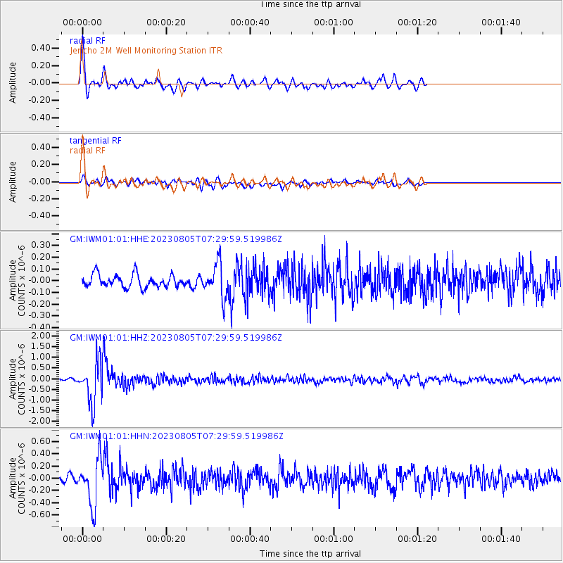
IWM01 Jericho 2M Well Monitoring Station - Earthquake Result Viewer

| Earthquake location: |
Santiago Del Estero Prov., Arg. |
| Earthquake latitude/longitude: |
-28.2/-63.2 |
| Earthquake time(UTC): |
2023/08/05 (217) 07:20:07 GMT |
| Earthquake Depth: |
598 km |
| Earthquake Magnitude: |
6.2 Mww |
| Earthquake Catalog/Contributor: |
NEIC PDE/us |
|
| Network: |
GM US Geological Survey Networks |
| Station: |
IWM01 Jericho 2M Well Monitoring Station |
| Lat/Lon: |
36.73 N/96.53 W |
| Elevation: |
328 m |
|
| Distance: |
71.8 deg |
| Az: |
332.298 deg |
| Baz: |
149.293 deg |
| Ray Param: |
0.052047726 |
| Estimated Moho Depth: |
38.5 km |
| Estimated Crust Vp/Vs: |
1.88 |
| Assumed Crust Vp: |
6.483 km/s |
| Estimated Crust Vs: |
3.448 km/s |
| Estimated Crust Poisson's Ratio: |
0.30 |
|
| Radial Match: |
80.811 % |
| Radial Bump: |
370 |
| Transverse Match: |
54.694252 % |
| Transverse Bump: |
400 |
| SOD ConfigId: |
31937991 |
| Insert Time: |
2023-08-19 07:32:22.984 +0000 |
| GWidth: |
2.5 |
| Max Bumps: |
400 |
| Tol: |
0.001 |
|
Signal To Noise
| Channel | StoN | STA | LTA |
| GM:IWM01:01:HHZ:20230805T07:29:59.519986Z | 18.729544 | 9.697825E-7 | 5.177822E-8 |
| GM:IWM01:01:HHN:20230805T07:29:59.519986Z | 9.820435 | 3.8686113E-7 | 3.9393484E-8 |
| GM:IWM01:01:HHE:20230805T07:29:59.519986Z | 2.8674753 | 1.5332954E-7 | 5.3471965E-8 |
| Arrivals |
| Ps | 5.4 SECOND |
| PpPs | 17 SECOND |
| PsPs/PpSs | 22 SECOND |


