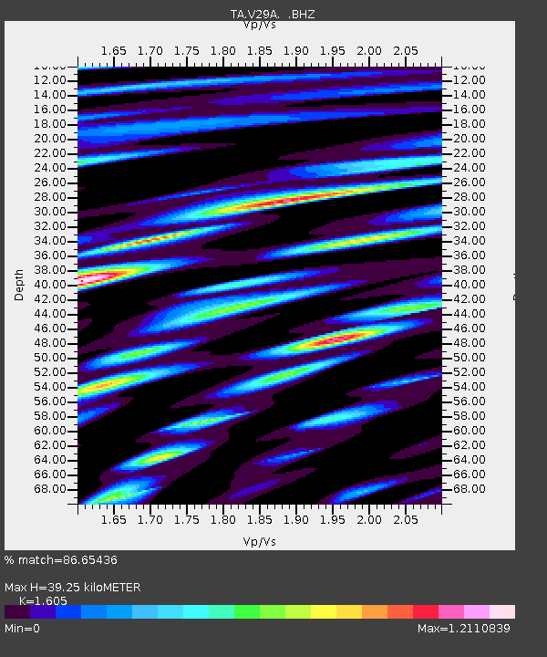
V29A Stinnett, TX, USA - Earthquake Result Viewer
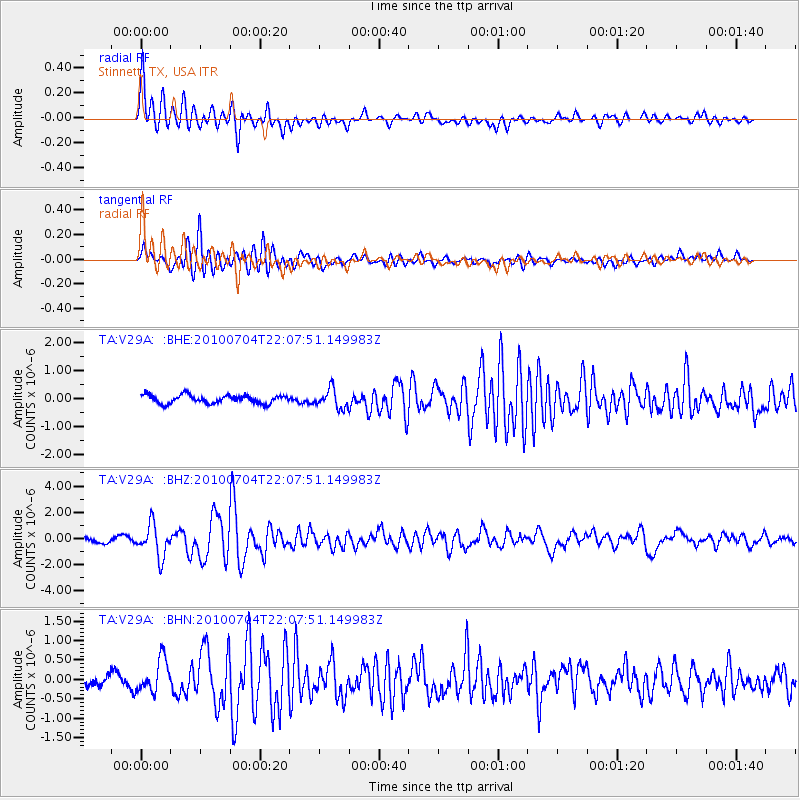
Earthquake location: Near East Coast Of Honshu, Japan
Earthquake latitude/longitude: 39.7/142.4
Earthquake time(UTC): 2010/07/04 (185) 21:55:51 GMT
Earthquake Depth: 27 km
Earthquake Magnitude: 6.4 MB, 6.1 MS, 6.3 MW, 6.2 MW
Earthquake Catalog/Contributor: WHDF/NEIC
Network: TA USArray Transportable Network (new EarthScope stations)
Station: V29A Stinnett, TX, USA
Lat/Lon: 35.87 N/101.52 W
Elevation: 953 m
Distance: 84.5 deg
Az: 47.108 deg
Baz: 315.895 deg
Ray Param: 0.045387626
Estimated Moho Depth: 39.25 km
Estimated Crust Vp/Vs: 1.61
Assumed Crust Vp: 6.426 km/s
Estimated Crust Vs: 4.004 km/s
Estimated Crust Poisson's Ratio: 0.18
Radial Match: 86.65436 %
Radial Bump: 400
Transverse Match: 82.56999 %
Transverse Bump: 400
SOD ConfigId: 319893
Insert Time: 2011-01-05 00:18:32.307 +0000
GWidth: 2.5
Max Bumps: 400
Tol: 0.001

Signal To Noise

ChannelStoNSTALTA
TA:V29A: :BHZ:20100704T22:07:51.149983Z6.3392771.224487E-61.9315878E-7
TA:V29A: :BHN:20100704T22:07:51.149983Z3.4067094.3128586E-71.2659896E-7
TA:V29A: :BHE:20100704T22:07:51.149983Z2.28587723.3701798E-71.4743486E-7
Arrivals
Ps3.8 SECOND
PpPs15 SECOND
PsPs/PpSs19 SECOND