You are here: Home > Network List > GS - US Geological Survey Networks Stations List
> Station OK052 Battle Ridge Rd, NW of Cushing, Oklahoma USA > Earthquake Result Viewer
OK052 Battle Ridge Rd, NW of Cushing, Oklahoma USA - Earthquake Result Viewer
| Earthquake location: |
Santiago Del Estero Prov., Arg. |
| Earthquake latitude/longitude: |
-28.2/-63.2 |
| Earthquake time(UTC): |
2023/08/05 (217) 07:20:07 GMT |
| Earthquake Depth: |
598 km |
| Earthquake Magnitude: |
6.2 Mww |
| Earthquake Catalog/Contributor: |
NEIC PDE/us |
|
| Network: |
GS US Geological Survey Networks |
| Station: |
OK052 Battle Ridge Rd, NW of Cushing, Oklahoma USA |
| Lat/Lon: |
36.00 N/96.80 W |
| Elevation: |
261 m |
|
| Distance: |
71.3 deg |
| Az: |
331.705 deg |
| Baz: |
148.946 deg |
| Ray Param: |
0.052386064 |
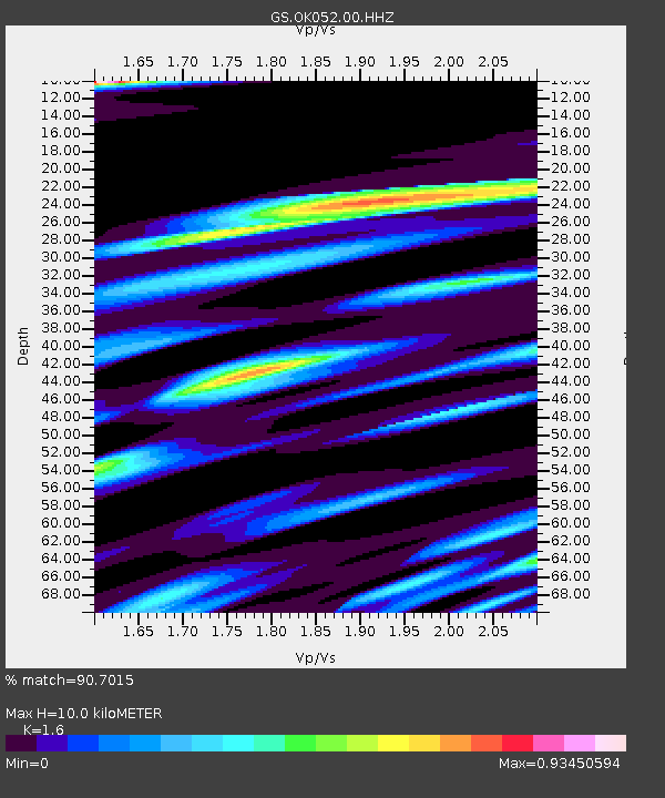
| Estimated Moho Depth: |
10.0 km |
| Estimated Crust Vp/Vs: |
1.60 |
| Assumed Crust Vp: |
6.426 km/s |
| Estimated Crust Vs: |
4.016 km/s |
| Estimated Crust Poisson's Ratio: |
0.18 |
|
| Radial Match: |
90.7015 % |
| Radial Bump: |
400 |
| Transverse Match: |
74.4933 % |
| Transverse Bump: |
400 |
| SOD ConfigId: |
31937991 |
| Insert Time: |
2023-08-19 07:33:13.079 +0000 |
| GWidth: |
2.5 |
| Max Bumps: |
400 |
| Tol: |
0.001 |
|

Signal To Noise
| Channel | StoN | STA | LTA |
| GS:OK052:00:HHZ:20230805T07:29:56.548978Z | 17.664436 | 1.2024217E-6 | 6.80702E-8 |
| GS:OK052:00:HH1:20230805T07:29:56.548978Z | 5.6013117 | 4.906106E-7 | 8.7588525E-8 |
| GS:OK052:00:HH2:20230805T07:29:56.548978Z | 5.9713044 | 3.9908278E-7 | 6.683343E-8 |
| Arrivals |
| Ps | 1.0 SECOND |
| PpPs | 3.9 SECOND |
| PsPs/PpSs | 4.9 SECOND |


