You are here: Home > Network List > IW - Intermountain West Stations List
> Station MOOW Moose Ponds, Wyoming, USA > Earthquake Result Viewer
MOOW Moose Ponds, Wyoming, USA - Earthquake Result Viewer
| Earthquake location: |
Santiago Del Estero Prov., Arg. |
| Earthquake latitude/longitude: |
-28.2/-63.2 |
| Earthquake time(UTC): |
2023/08/05 (217) 07:20:07 GMT |
| Earthquake Depth: |
598 km |
| Earthquake Magnitude: |
6.2 Mww |
| Earthquake Catalog/Contributor: |
NEIC PDE/us |
|
| Network: |
IW Intermountain West |
| Station: |
MOOW Moose Ponds, Wyoming, USA |
| Lat/Lon: |
43.75 N/110.74 W |
| Elevation: |
2128 m |
|
| Distance: |
83.8 deg |
| Az: |
327.457 deg |
| Baz: |
139.076 deg |
| Ray Param: |
0.044142824 |
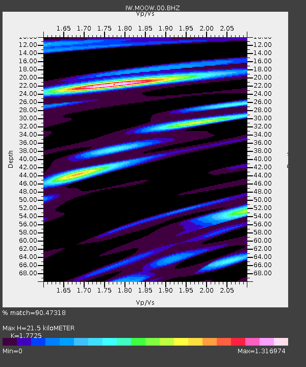
| Estimated Moho Depth: |
21.5 km |
| Estimated Crust Vp/Vs: |
1.77 |
| Assumed Crust Vp: |
6.207 km/s |
| Estimated Crust Vs: |
3.502 km/s |
| Estimated Crust Poisson's Ratio: |
0.27 |
|
| Radial Match: |
90.47318 % |
| Radial Bump: |
400 |
| Transverse Match: |
84.59326 % |
| Transverse Bump: |
400 |
| SOD ConfigId: |
31937991 |
| Insert Time: |
2023-08-19 07:34:18.986 +0000 |
| GWidth: |
2.5 |
| Max Bumps: |
400 |
| Tol: |
0.001 |
|
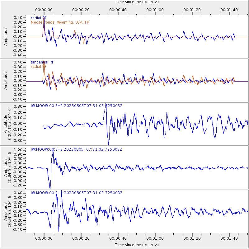
Signal To Noise
| Channel | StoN | STA | LTA |
| IW:MOOW:00:BHZ:20230805T07:31:03.725003Z | 14.4243145 | 6.3931884E-7 | 4.4322306E-8 |
| IW:MOOW:00:BH1:20230805T07:31:03.725003Z | 5.452569 | 1.3875128E-7 | 2.5446955E-8 |
| IW:MOOW:00:BH2:20230805T07:31:03.725003Z | 6.61732 | 1.7162871E-7 | 2.5936288E-8 |
| Arrivals |
| Ps | 2.7 SECOND |
| PpPs | 9.4 SECOND |
| PsPs/PpSs | 12 SECOND |


