You are here: Home > Network List > TA - USArray Transportable Network (new EarthScope stations) Stations List
> Station ABTX Abilene, Hawley, TX, USA > Earthquake Result Viewer
ABTX Abilene, Hawley, TX, USA - Earthquake Result Viewer

| Earthquake location: |
Near East Coast Of Honshu, Japan |
| Earthquake latitude/longitude: |
39.7/142.4 |
| Earthquake time(UTC): |
2010/07/04 (185) 21:55:51 GMT |
| Earthquake Depth: |
27 km |
| Earthquake Magnitude: |
6.4 MB, 6.1 MS, 6.3 MW, 6.2 MW |
| Earthquake Catalog/Contributor: |
WHDF/NEIC |
|
| Network: |
TA USArray Transportable Network (new EarthScope stations) |
| Station: |
ABTX Abilene, Hawley, TX, USA |
| Lat/Lon: |
32.62 N/99.64 W |
| Elevation: |
502 m |
|
| Distance: |
87.9 deg |
| Az: |
48.215 deg |
| Baz: |
317.02 deg |
| Ray Param: |
0.042919964 |
| Estimated Moho Depth: |
31.5 km |
| Estimated Crust Vp/Vs: |
2.09 |
| Assumed Crust Vp: |
6.426 km/s |
| Estimated Crust Vs: |
3.075 km/s |
| Estimated Crust Poisson's Ratio: |
0.35 |
|
| Radial Match: |
94.04199 % |
| Radial Bump: |
321 |
| Transverse Match: |
71.36809 % |
| Transverse Bump: |
385 |
| SOD ConfigId: |
319893 |
| Insert Time: |
2011-01-05 00:19:33.850 +0000 |
| GWidth: |
2.5 |
| Max Bumps: |
400 |
| Tol: |
0.001 |
|
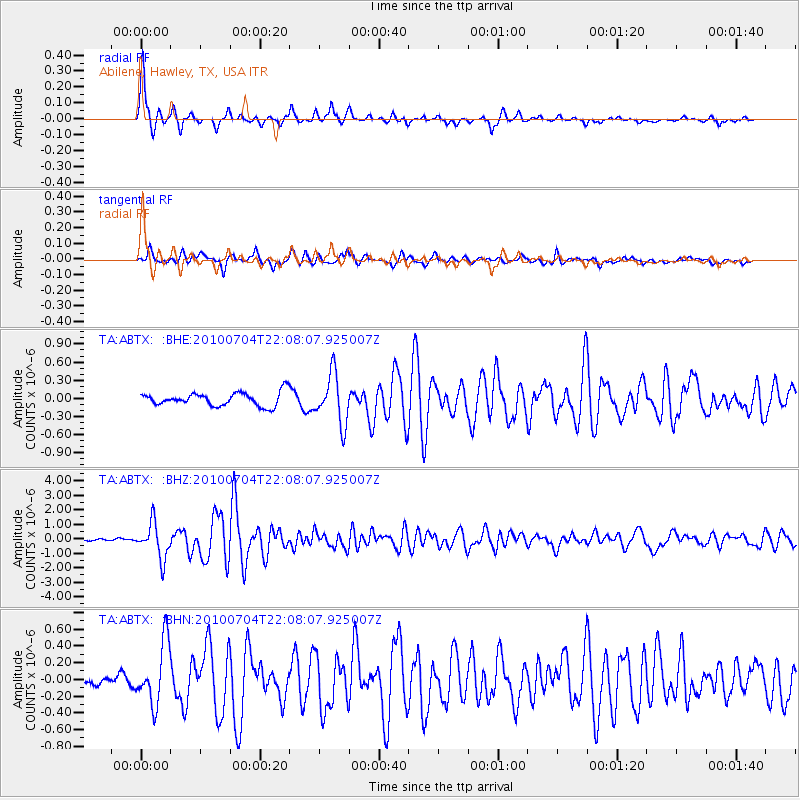
Signal To Noise
| Channel | StoN | STA | LTA |
| TA:ABTX: :BHZ:20100704T22:08:07.925007Z | 13.811609 | 1.2161547E-6 | 8.805308E-8 |
| TA:ABTX: :BHN:20100704T22:08:07.925007Z | 5.4604454 | 3.651112E-7 | 6.686473E-8 |
| TA:ABTX: :BHE:20100704T22:08:07.925007Z | 3.706021 | 4.0926741E-7 | 1.10433106E-7 |
| Arrivals |
| Ps | 5.4 SECOND |
| PpPs | 15 SECOND |
| PsPs/PpSs | 20 SECOND |


