You are here: Home > Network List > TA - USArray Transportable Network (new EarthScope stations) Stations List
> Station 431A Sonora, TX, USA > Earthquake Result Viewer
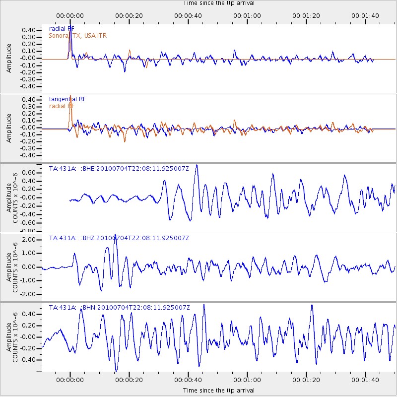
431A Sonora, TX, USA - Earthquake Result Viewer
*The percent match for this event was below the threshold and hence no stack was calculated.
| Earthquake location: |
Near East Coast Of Honshu, Japan |
| Earthquake latitude/longitude: |
39.7/142.4 |
| Earthquake time(UTC): |
2010/07/04 (185) 21:55:51 GMT |
| Earthquake Depth: |
27 km |
| Earthquake Magnitude: |
6.4 MB, 6.1 MS, 6.3 MW, 6.2 MW |
| Earthquake Catalog/Contributor: |
WHDF/NEIC |
|
| Network: |
TA USArray Transportable Network (new EarthScope stations) |
| Station: |
431A Sonora, TX, USA |
| Lat/Lon: |
30.68 N/100.61 W |
| Elevation: |
700 m |
|
| Distance: |
88.8 deg |
| Az: |
50.141 deg |
| Baz: |
316.571 deg |
| Ray Param: |
$rayparam |
*The percent match for this event was below the threshold and hence was not used in the summary stack. |
|
| Radial Match: |
78.22333 % |
| Radial Bump: |
400 |
| Transverse Match: |
71.20048 % |
| Transverse Bump: |
388 |
| SOD ConfigId: |
319893 |
| Insert Time: |
2011-01-05 00:19:58.521 +0000 |
| GWidth: |
2.5 |
| Max Bumps: |
400 |
| Tol: |
0.001 |
|
Signal To Noise
| Channel | StoN | STA | LTA |
| TA:431A: :BHZ:20100704T22:08:11.925007Z | 5.037418 | 6.344648E-7 | 1.2595041E-7 |
| TA:431A: :BHN:20100704T22:08:11.925007Z | 2.3908634 | 2.723246E-7 | 1.139022E-7 |
| TA:431A: :BHE:20100704T22:08:11.925007Z | 5.281433 | 2.9552285E-7 | 5.5955052E-8 |
| Arrivals |
| Ps | |
| PpPs | |
| PsPs/PpSs | |


