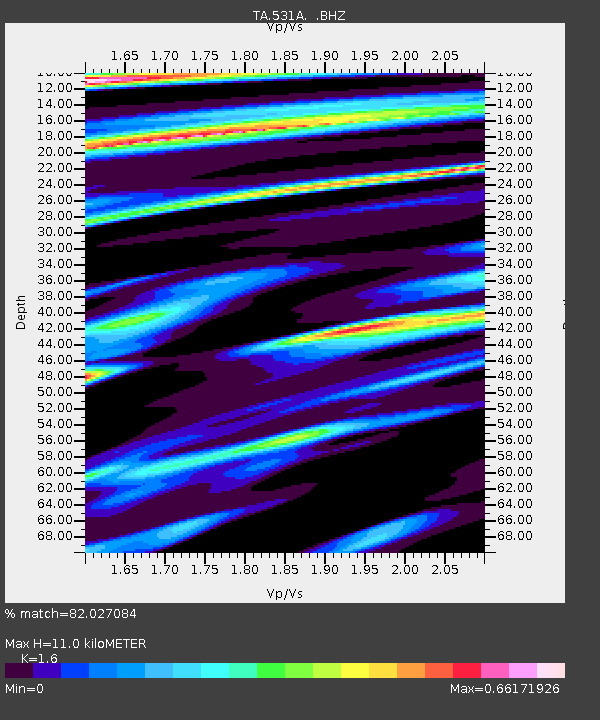
531A Rocksprings, TX, USA - Earthquake Result Viewer
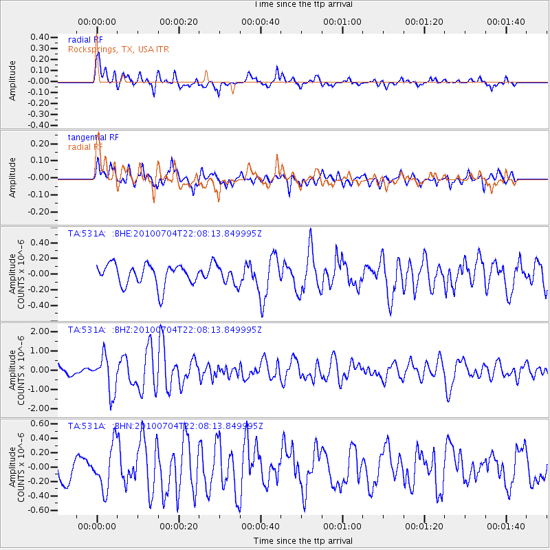
Earthquake location: Near East Coast Of Honshu, Japan
Earthquake latitude/longitude: 39.7/142.4
Earthquake time(UTC): 2010/07/04 (185) 21:55:51 GMT
Earthquake Depth: 27 km
Earthquake Magnitude: 6.4 MB, 6.1 MS, 6.3 MW, 6.2 MW
Earthquake Catalog/Contributor: WHDF/NEIC
Network: TA USArray Transportable Network (new EarthScope stations)
Station: 531A Rocksprings, TX, USA
Lat/Lon: 30.16 N/100.55 W
Elevation: 661 m
Distance: 89.2 deg
Az: 50.457 deg
Baz: 316.608 deg
Ray Param: 0.041988857
Estimated Moho Depth: 11.0 km
Estimated Crust Vp/Vs: 1.60
Assumed Crust Vp: 6.38 km/s
Estimated Crust Vs: 3.988 km/s
Estimated Crust Poisson's Ratio: 0.18
Radial Match: 82.027084 %
Radial Bump: 400
Transverse Match: 78.04734 %
Transverse Bump: 400
SOD ConfigId: 319893
Insert Time: 2011-01-05 00:20:10.593 +0000
GWidth: 2.5
Max Bumps: 400
Tol: 0.001

Signal To Noise

ChannelStoNSTALTA
TA:531A: :BHZ:20100704T22:08:13.849995Z4.14590269.744296E-72.3503436E-7
TA:531A: :BHN:20100704T22:08:13.849995Z1.83057253.182774E-71.7386768E-7
TA:531A: :BHE:20100704T22:08:13.849995Z0.83908911.12541194E-71.3412306E-7
Arrivals
Ps1.1 SECOND
PpPs4.4 SECOND
PsPs/PpSs5.4 SECOND