You are here: Home > Network List > N4 - Central and EAstern US Network Stations List
> Station S39B Bolivar, MO, USA > Earthquake Result Viewer
S39B Bolivar, MO, USA - Earthquake Result Viewer
| Earthquake location: |
Santiago Del Estero Prov., Arg. |
| Earthquake latitude/longitude: |
-28.2/-63.2 |
| Earthquake time(UTC): |
2023/08/05 (217) 07:20:07 GMT |
| Earthquake Depth: |
598 km |
| Earthquake Magnitude: |
6.2 Mww |
| Earthquake Catalog/Contributor: |
NEIC PDE/us |
|
| Network: |
N4 Central and EAstern US Network |
| Station: |
S39B Bolivar, MO, USA |
| Lat/Lon: |
37.69 N/93.32 W |
| Elevation: |
340 m |
|
| Distance: |
71.4 deg |
| Az: |
335.148 deg |
| Baz: |
152.126 deg |
| Ray Param: |
0.05232082 |
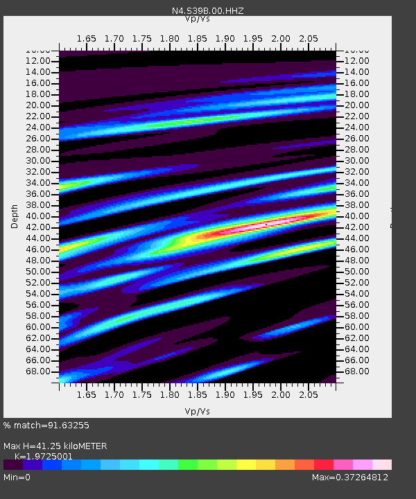
| Estimated Moho Depth: |
41.25 km |
| Estimated Crust Vp/Vs: |
1.97 |
| Assumed Crust Vp: |
6.53 km/s |
| Estimated Crust Vs: |
3.311 km/s |
| Estimated Crust Poisson's Ratio: |
0.33 |
|
| Radial Match: |
91.63255 % |
| Radial Bump: |
400 |
| Transverse Match: |
74.40766 % |
| Transverse Bump: |
400 |
| SOD ConfigId: |
31937991 |
| Insert Time: |
2023-08-19 07:38:13.617 +0000 |
| GWidth: |
2.5 |
| Max Bumps: |
400 |
| Tol: |
0.001 |
|

Signal To Noise
| Channel | StoN | STA | LTA |
| N4:S39B:00:HHZ:20230805T07:29:57.128995Z | 27.949528 | 1.3288669E-6 | 4.7545235E-8 |
| N4:S39B:00:HH1:20230805T07:29:57.128995Z | 10.26264 | 4.0130337E-7 | 3.9103327E-8 |
| N4:S39B:00:HH2:20230805T07:29:57.128995Z | 5.6395845 | 2.474966E-7 | 4.388561E-8 |
| Arrivals |
| Ps | 6.3 SECOND |
| PpPs | 18 SECOND |
| PsPs/PpSs | 25 SECOND |


