You are here: Home > Network List > N4 - Central and EAstern US Network Stations List
> Station Z38B Mount Pleasant, TX, USA > Earthquake Result Viewer
Z38B Mount Pleasant, TX, USA - Earthquake Result Viewer
| Earthquake location: |
Santiago Del Estero Prov., Arg. |
| Earthquake latitude/longitude: |
-28.2/-63.2 |
| Earthquake time(UTC): |
2023/08/05 (217) 07:20:07 GMT |
| Earthquake Depth: |
598 km |
| Earthquake Magnitude: |
6.2 Mww |
| Earthquake Catalog/Contributor: |
NEIC PDE/us |
|
| Network: |
N4 Central and EAstern US Network |
| Station: |
Z38B Mount Pleasant, TX, USA |
| Lat/Lon: |
33.26 N/94.99 W |
| Elevation: |
115 m |
|
| Distance: |
68.2 deg |
| Az: |
331.602 deg |
| Baz: |
149.938 deg |
| Ray Param: |
0.05434587 |
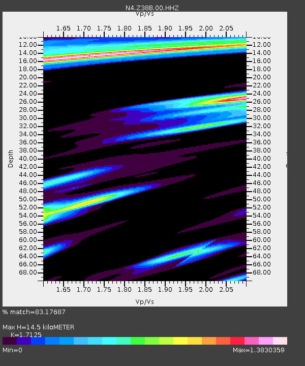
| Estimated Moho Depth: |
14.5 km |
| Estimated Crust Vp/Vs: |
1.71 |
| Assumed Crust Vp: |
6.245 km/s |
| Estimated Crust Vs: |
3.647 km/s |
| Estimated Crust Poisson's Ratio: |
0.24 |
|
| Radial Match: |
83.17687 % |
| Radial Bump: |
400 |
| Transverse Match: |
59.397747 % |
| Transverse Bump: |
400 |
| SOD ConfigId: |
31937991 |
| Insert Time: |
2023-08-19 07:39:16.823 +0000 |
| GWidth: |
2.5 |
| Max Bumps: |
400 |
| Tol: |
0.001 |
|

Signal To Noise
| Channel | StoN | STA | LTA |
| N4:Z38B:00:HHZ:20230805T07:29:38.149014Z | 10.834399 | 1.1730654E-6 | 1.082723E-7 |
| N4:Z38B:00:HH1:20230805T07:29:38.149014Z | 3.5327392 | 3.6508504E-7 | 1.0334334E-7 |
| N4:Z38B:00:HH2:20230805T07:29:38.149014Z | 2.2218256 | 2.5498036E-7 | 1.1476165E-7 |
| Arrivals |
| Ps | 1.7 SECOND |
| PpPs | 6.1 SECOND |
| PsPs/PpSs | 7.8 SECOND |


