You are here: Home > Network List > O2 - Oklahoma Consolidated Temporary Seismic Networks Stations List
> Station DRIP Dripping spring state park, Oklahoma, USA > Earthquake Result Viewer
DRIP Dripping spring state park, Oklahoma, USA - Earthquake Result Viewer
| Earthquake location: |
Santiago Del Estero Prov., Arg. |
| Earthquake latitude/longitude: |
-28.2/-63.2 |
| Earthquake time(UTC): |
2023/08/05 (217) 07:20:07 GMT |
| Earthquake Depth: |
598 km |
| Earthquake Magnitude: |
6.2 Mww |
| Earthquake Catalog/Contributor: |
NEIC PDE/us |
|
| Network: |
O2 Oklahoma Consolidated Temporary Seismic Networks |
| Station: |
DRIP Dripping spring state park, Oklahoma, USA |
| Lat/Lon: |
35.61 N/96.07 W |
| Elevation: |
243 m |
|
| Distance: |
70.7 deg |
| Az: |
332.043 deg |
| Baz: |
149.486 deg |
| Ray Param: |
0.052786235 |
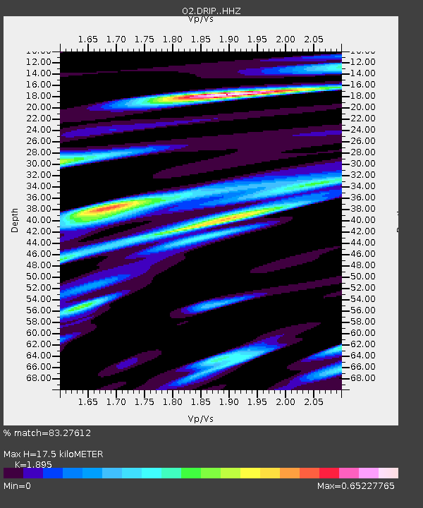
| Estimated Moho Depth: |
17.5 km |
| Estimated Crust Vp/Vs: |
1.89 |
| Assumed Crust Vp: |
6.426 km/s |
| Estimated Crust Vs: |
3.391 km/s |
| Estimated Crust Poisson's Ratio: |
0.31 |
|
| Radial Match: |
83.27612 % |
| Radial Bump: |
400 |
| Transverse Match: |
67.20943 % |
| Transverse Bump: |
400 |
| SOD ConfigId: |
31937991 |
| Insert Time: |
2023-08-19 07:42:04.988 +0000 |
| GWidth: |
2.5 |
| Max Bumps: |
400 |
| Tol: |
0.001 |
|

Signal To Noise
| Channel | StoN | STA | LTA |
| O2:DRIP: :HHZ:20230805T07:29:52.844998Z | 26.047611 | 1.578502E-6 | 6.060064E-8 |
| O2:DRIP: :HHN:20230805T07:29:52.844998Z | 4.5961485 | 3.5710428E-7 | 7.769642E-8 |
| O2:DRIP: :HHE:20230805T07:29:52.844998Z | 4.6810536 | 3.7270078E-7 | 7.961899E-8 |
| Arrivals |
| Ps | 2.5 SECOND |
| PpPs | 7.6 SECOND |
| PsPs/PpSs | 10 SECOND |


