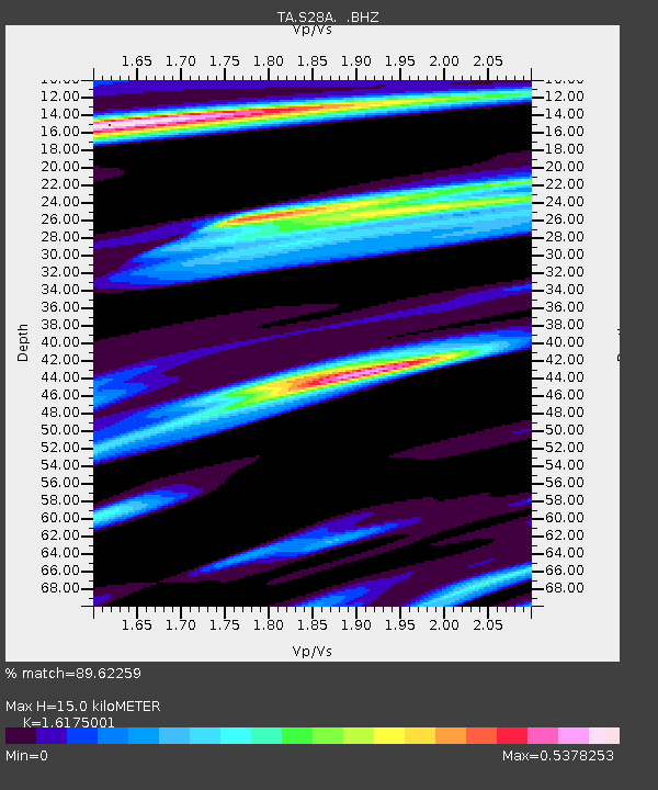
S28A Manter, KS, USA - Earthquake Result Viewer
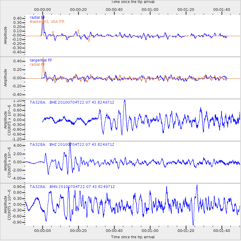
Earthquake location: Near East Coast Of Honshu, Japan
Earthquake latitude/longitude: 39.7/142.4
Earthquake time(UTC): 2010/07/04 (185) 21:55:51 GMT
Earthquake Depth: 27 km
Earthquake Magnitude: 6.4 MB, 6.1 MS, 6.3 MW, 6.2 MW
Earthquake Catalog/Contributor: WHDF/NEIC
Network: TA USArray Transportable Network (new EarthScope stations)
Station: S28A Manter, KS, USA
Lat/Lon: 37.59 N/101.90 W
Elevation: 1064 m
Distance: 83.1 deg
Az: 46.123 deg
Baz: 315.564 deg
Ray Param: 0.046403766
Estimated Moho Depth: 15.0 km
Estimated Crust Vp/Vs: 1.62
Assumed Crust Vp: 6.483 km/s
Estimated Crust Vs: 4.008 km/s
Estimated Crust Poisson's Ratio: 0.19
Radial Match: 89.62259 %
Radial Bump: 367
Transverse Match: 70.09389 %
Transverse Bump: 400
SOD ConfigId: 319893
Insert Time: 2011-01-05 00:23:03.674 +0000
GWidth: 2.5
Max Bumps: 400
Tol: 0.001

Signal To Noise

ChannelStoNSTALTA
TA:S28A: :BHZ:20100704T22:07:43.824971Z7.9172831.1992383E-61.5147094E-7
TA:S28A: :BHN:20100704T22:07:43.824971Z2.35759434.822865E-72.0456723E-7
TA:S28A: :BHE:20100704T22:07:43.824971Z3.2627314.0493384E-71.2410887E-7
Arrivals
Ps1.5 SECOND
PpPs5.9 SECOND
PsPs/PpSs7.4 SECOND