You are here: Home > Network List > GS - US Geological Survey Networks Stations List
> Station KAN10 Keim Farm > Earthquake Result Viewer
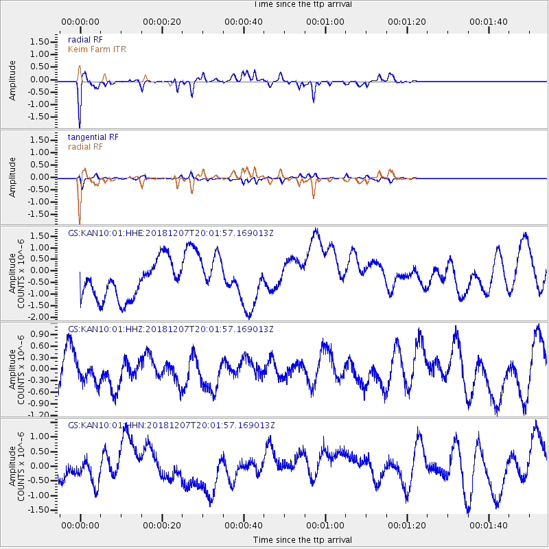
KAN10 Keim Farm - Earthquake Result Viewer
*The percent match for this event was below the threshold and hence no stack was calculated.
| Earthquake location: |
Southern Alaska |
| Earthquake latitude/longitude: |
61.3/-150.0 |
| Earthquake time(UTC): |
2018/12/07 (341) 19:54:54 GMT |
| Earthquake Depth: |
29 km |
| Earthquake Magnitude: |
3.5 ML |
| Earthquake Catalog/Contributor: |
NEIC PDE/ak |
|
| Network: |
GS US Geological Survey Networks |
| Station: |
KAN10 Keim Farm |
| Lat/Lon: |
37.12 N/98.10 W |
| Elevation: |
417 m |
|
| Distance: |
40.2 deg |
| Az: |
102.719 deg |
| Baz: |
323.936 deg |
| Ray Param: |
$rayparam |
*The percent match for this event was below the threshold and hence was not used in the summary stack. |
|
| Radial Match: |
61.412144 % |
| Radial Bump: |
260 |
| Transverse Match: |
54.136505 % |
| Transverse Bump: |
253 |
| SOD ConfigId: |
3201911 |
| Insert Time: |
2018-12-21 20:09:35.060 +0000 |
| GWidth: |
2.5 |
| Max Bumps: |
400 |
| Tol: |
0.001 |
|
Signal To Noise
| Channel | StoN | STA | LTA |
| GS:KAN10:01:HHZ:20181207T20:01:57.169013Z | 0.70784366 | 2.6291147E-7 | 3.714259E-7 |
| GS:KAN10:01:HHN:20181207T20:01:57.169013Z | 1.412783 | 7.001852E-7 | 4.95607E-7 |
| GS:KAN10:01:HHE:20181207T20:01:57.169013Z | 1.2378137 | 9.4368465E-7 | 7.623802E-7 |
| Arrivals |
| Ps | |
| PpPs | |
| PsPs/PpSs | |


