You are here: Home > Network List > TX - Texas Seismological Network Stations List
> Station PB11 China Draw > Earthquake Result Viewer
PB11 China Draw - Earthquake Result Viewer
| Earthquake location: |
Santiago Del Estero Prov., Arg. |
| Earthquake latitude/longitude: |
-28.2/-63.2 |
| Earthquake time(UTC): |
2023/08/05 (217) 07:20:07 GMT |
| Earthquake Depth: |
598 km |
| Earthquake Magnitude: |
6.2 Mww |
| Earthquake Catalog/Contributor: |
NEIC PDE/us |
|
| Network: |
TX Texas Seismological Network |
| Station: |
PB11 China Draw |
| Lat/Lon: |
31.94 N/104.03 W |
| Elevation: |
915 m |
|
| Distance: |
71.3 deg |
| Az: |
324.058 deg |
| Baz: |
142.465 deg |
| Ray Param: |
0.052355792 |
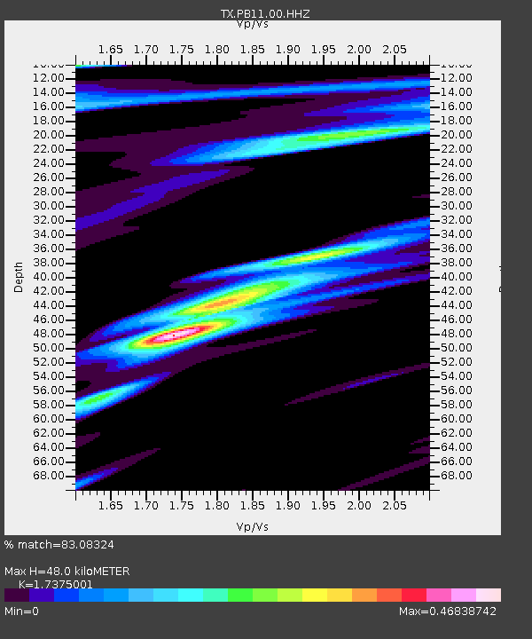
| Estimated Moho Depth: |
48.0 km |
| Estimated Crust Vp/Vs: |
1.74 |
| Assumed Crust Vp: |
6.361 km/s |
| Estimated Crust Vs: |
3.661 km/s |
| Estimated Crust Poisson's Ratio: |
0.25 |
|
| Radial Match: |
83.08324 % |
| Radial Bump: |
400 |
| Transverse Match: |
63.078213 % |
| Transverse Bump: |
400 |
| SOD ConfigId: |
31937991 |
| Insert Time: |
2023-08-19 07:49:14.989 +0000 |
| GWidth: |
2.5 |
| Max Bumps: |
400 |
| Tol: |
0.001 |
|

Signal To Noise
| Channel | StoN | STA | LTA |
| TX:PB11:00:HHZ:20230805T07:29:56.810025Z | 15.117299 | 9.3257E-7 | 6.168893E-8 |
| TX:PB11:00:HH1:20230805T07:29:56.810025Z | 2.6445036 | 1.4472786E-7 | 5.47278E-8 |
| TX:PB11:00:HH2:20230805T07:29:56.810025Z | 2.6992755 | 1.8181146E-7 | 6.735565E-8 |
| Arrivals |
| Ps | 5.8 SECOND |
| PpPs | 20 SECOND |
| PsPs/PpSs | 26 SECOND |


