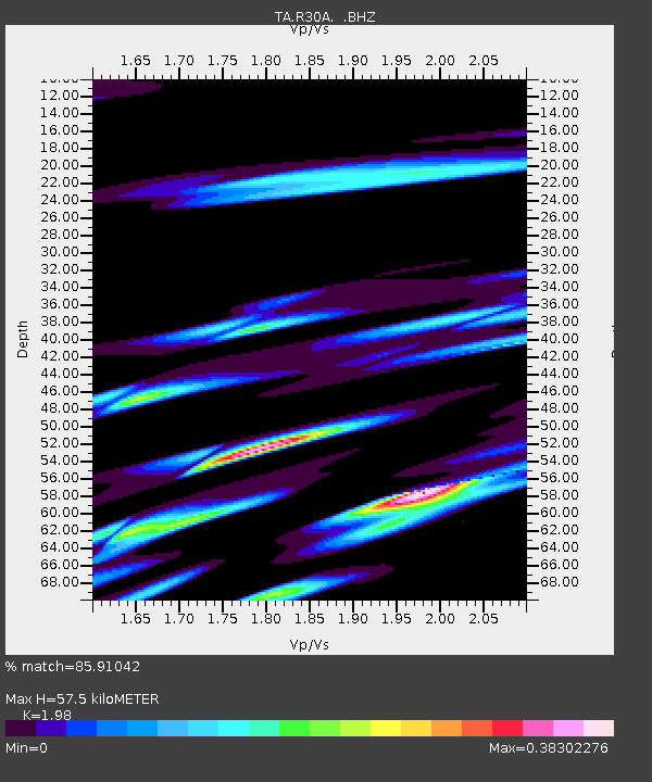
R30A Dighton, KS, USA - Earthquake Result Viewer
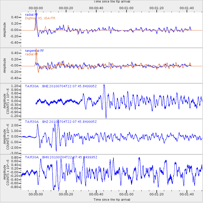
Earthquake location: Near East Coast Of Honshu, Japan
Earthquake latitude/longitude: 39.7/142.4
Earthquake time(UTC): 2010/07/04 (185) 21:55:51 GMT
Earthquake Depth: 27 km
Earthquake Magnitude: 6.4 MB, 6.1 MS, 6.3 MW, 6.2 MW
Earthquake Catalog/Contributor: WHDF/NEIC
Network: TA USArray Transportable Network (new EarthScope stations)
Station: R30A Dighton, KS, USA
Lat/Lon: 38.28 N/100.28 W
Elevation: 776 m
Distance: 83.5 deg
Az: 44.71 deg
Baz: 316.392 deg
Ray Param: 0.04612589
Estimated Moho Depth: 57.5 km
Estimated Crust Vp/Vs: 1.98
Assumed Crust Vp: 6.483 km/s
Estimated Crust Vs: 3.274 km/s
Estimated Crust Poisson's Ratio: 0.33
Radial Match: 85.91042 %
Radial Bump: 400
Transverse Match: 79.585236 %
Transverse Bump: 400
SOD ConfigId: 319893
Insert Time: 2011-01-05 00:23:29.822 +0000
GWidth: 2.5
Max Bumps: 400
Tol: 0.001

Signal To Noise

ChannelStoNSTALTA
TA:R30A: :BHZ:20100704T22:07:45.849995Z17.7017921.0286515E-65.811002E-8
TA:R30A: :BHN:20100704T22:07:45.849995Z2.83398683.4352266E-71.2121534E-7
TA:R30A: :BHE:20100704T22:07:45.849995Z2.84376673.252669E-71.14378906E-7
Arrivals
Ps8.9 SECOND
PpPs26 SECOND
PsPs/PpSs35 SECOND