You are here: Home > Network List > TA - USArray Transportable Network (new EarthScope stations) Stations List
> Station U28A Mallet, Rita Blanca National Grassland, TX, USA > Earthquake Result Viewer
U28A Mallet, Rita Blanca National Grassland, TX, USA - Earthquake Result Viewer
| Earthquake location: |
Near East Coast Of Honshu, Japan |
| Earthquake latitude/longitude: |
39.7/142.4 |
| Earthquake time(UTC): |
2010/07/04 (185) 21:55:51 GMT |
| Earthquake Depth: |
27 km |
| Earthquake Magnitude: |
6.4 MB, 6.1 MS, 6.3 MW, 6.2 MW |
| Earthquake Catalog/Contributor: |
WHDF/NEIC |
|
| Network: |
TA USArray Transportable Network (new EarthScope stations) |
| Station: |
U28A Mallet, Rita Blanca National Grassland, TX, USA |
| Lat/Lon: |
36.38 N/102.22 W |
| Elevation: |
1165 m |
|
| Distance: |
83.8 deg |
| Az: |
47.163 deg |
| Baz: |
315.488 deg |
| Ray Param: |
0.04592147 |
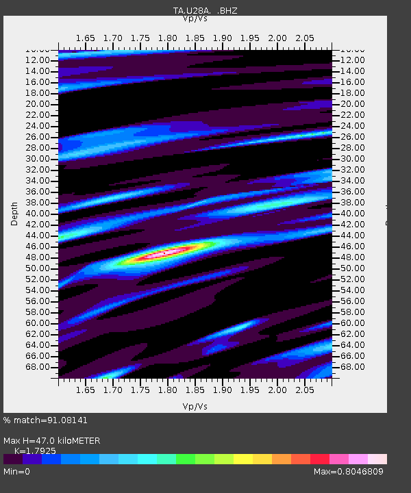
| Estimated Moho Depth: |
47.0 km |
| Estimated Crust Vp/Vs: |
1.79 |
| Assumed Crust Vp: |
6.306 km/s |
| Estimated Crust Vs: |
3.518 km/s |
| Estimated Crust Poisson's Ratio: |
0.27 |
|
| Radial Match: |
91.08141 % |
| Radial Bump: |
339 |
| Transverse Match: |
76.30849 % |
| Transverse Bump: |
400 |
| SOD ConfigId: |
319893 |
| Insert Time: |
2011-01-05 00:23:39.519 +0000 |
| GWidth: |
2.5 |
| Max Bumps: |
400 |
| Tol: |
0.001 |
|

Signal To Noise
| Channel | StoN | STA | LTA |
| TA:U28A: :BHZ:20100704T22:07:47.324971Z | 10.298092 | 1.3243524E-6 | 1.2860173E-7 |
| TA:U28A: :BHN:20100704T22:07:47.324971Z | 3.9669917 | 5.343649E-7 | 1.347028E-7 |
| TA:U28A: :BHE:20100704T22:07:47.324971Z | 4.0919223 | 2.816321E-7 | 6.882636E-8 |
| Arrivals |
| Ps | 6.1 SECOND |
| PpPs | 20 SECOND |
| PsPs/PpSs | 26 SECOND |


