You are here: Home > Network List > US - United States National Seismic Network Stations List
> Station MNTX Cornudas Mountains, Texas, USA > Earthquake Result Viewer
MNTX Cornudas Mountains, Texas, USA - Earthquake Result Viewer
*The percent match for this event was below the threshold and hence no stack was calculated.
| Earthquake location: |
Southern Alaska |
| Earthquake latitude/longitude: |
61.3/-150.0 |
| Earthquake time(UTC): |
2018/12/07 (341) 19:54:54 GMT |
| Earthquake Depth: |
29 km |
| Earthquake Magnitude: |
3.5 ML |
| Earthquake Catalog/Contributor: |
NEIC PDE/ak |
|
| Network: |
US United States National Seismic Network |
| Station: |
MNTX Cornudas Mountains, Texas, USA |
| Lat/Lon: |
31.70 N/105.38 W |
| Elevation: |
404 m |
|
| Distance: |
41.4 deg |
| Az: |
114.996 deg |
| Baz: |
329.143 deg |
| Ray Param: |
$rayparam |
*The percent match for this event was below the threshold and hence was not used in the summary stack. |
|
| Radial Match: |
47.38855 % |
| Radial Bump: |
400 |
| Transverse Match: |
80.646095 % |
| Transverse Bump: |
287 |
| SOD ConfigId: |
3201911 |
| Insert Time: |
2018-12-21 20:12:07.499 +0000 |
| GWidth: |
2.5 |
| Max Bumps: |
400 |
| Tol: |
0.001 |
|
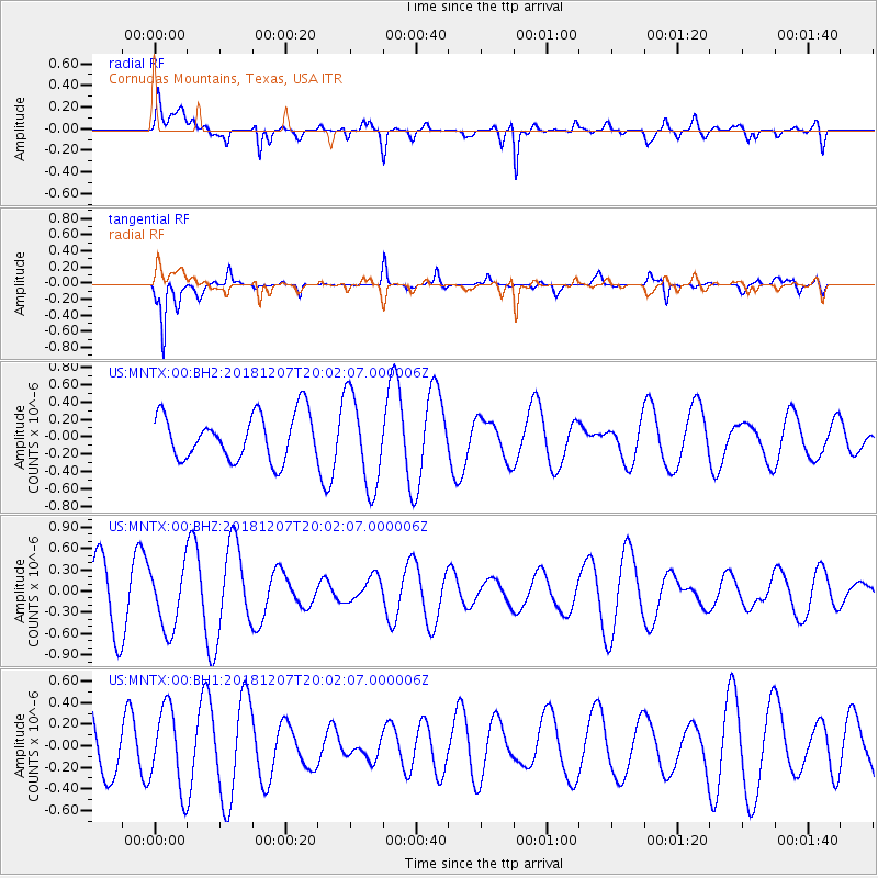
Signal To Noise
| Channel | StoN | STA | LTA |
| US:MNTX:00:BHZ:20181207T20:02:07.000006Z | 1.43467 | 4.363699E-7 | 3.041605E-7 |
| US:MNTX:00:BH1:20181207T20:02:07.000006Z | 1.5082566 | 3.7372573E-7 | 2.4778657E-7 |
| US:MNTX:00:BH2:20181207T20:02:07.000006Z | 2.0352356 | 5.3443534E-7 | 2.6259139E-7 |
| Arrivals |
| Ps | |
| PpPs | |
| PsPs/PpSs | |


