You are here: Home > Network List > TA - USArray Transportable Network (new EarthScope stations) Stations List
> Station L29A Maesberg Ranch, Thedford, NE, USA > Earthquake Result Viewer
L29A Maesberg Ranch, Thedford, NE, USA - Earthquake Result Viewer
| Earthquake location: |
Near East Coast Of Honshu, Japan |
| Earthquake latitude/longitude: |
39.7/142.4 |
| Earthquake time(UTC): |
2010/07/04 (185) 21:55:51 GMT |
| Earthquake Depth: |
27 km |
| Earthquake Magnitude: |
6.4 MB, 6.1 MS, 6.3 MW, 6.2 MW |
| Earthquake Catalog/Contributor: |
WHDF/NEIC |
|
| Network: |
TA USArray Transportable Network (new EarthScope stations) |
| Station: |
L29A Maesberg Ranch, Thedford, NE, USA |
| Lat/Lon: |
42.06 N/100.48 W |
| Elevation: |
901 m |
|
| Distance: |
80.7 deg |
| Az: |
42.182 deg |
| Baz: |
315.913 deg |
| Ray Param: |
0.048100036 |
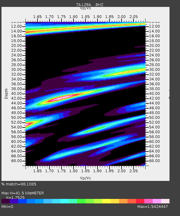
| Estimated Moho Depth: |
41.5 km |
| Estimated Crust Vp/Vs: |
1.75 |
| Assumed Crust Vp: |
6.483 km/s |
| Estimated Crust Vs: |
3.699 km/s |
| Estimated Crust Poisson's Ratio: |
0.26 |
|
| Radial Match: |
88.1085 % |
| Radial Bump: |
400 |
| Transverse Match: |
76.4812 % |
| Transverse Bump: |
400 |
| SOD ConfigId: |
319893 |
| Insert Time: |
2011-01-05 00:25:43.401 +0000 |
| GWidth: |
2.5 |
| Max Bumps: |
400 |
| Tol: |
0.001 |
|

Signal To Noise
| Channel | StoN | STA | LTA |
| TA:L29A: :BHZ:20100704T22:07:31.050007Z | 9.670399 | 1.3364709E-6 | 1.3820225E-7 |
| TA:L29A: :BHN:20100704T22:07:31.050007Z | 2.0454214 | 6.241956E-7 | 3.0516728E-7 |
| TA:L29A: :BHE:20100704T22:07:31.050007Z | 2.0022717 | 5.022046E-7 | 2.508174E-7 |
| Arrivals |
| Ps | 5.0 SECOND |
| PpPs | 17 SECOND |
| PsPs/PpSs | 22 SECOND |


