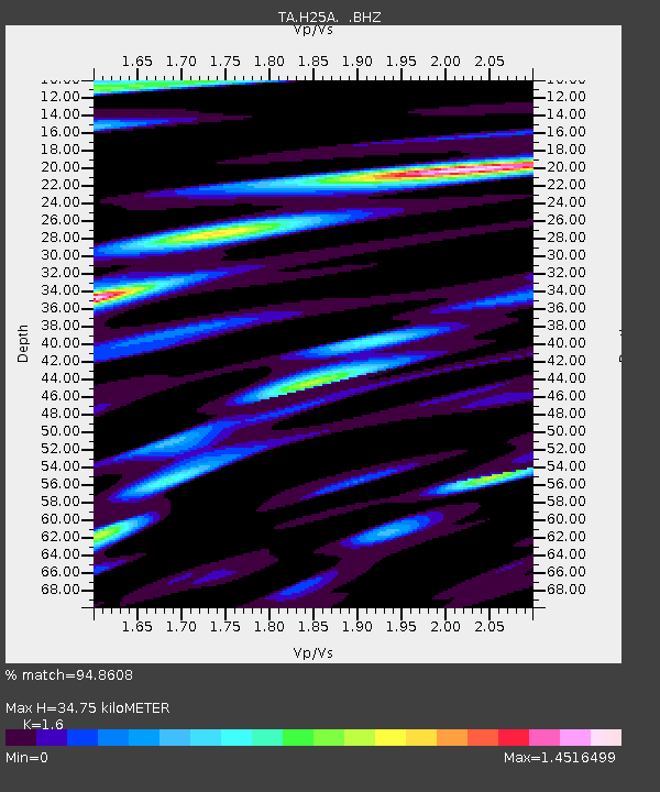
H25A Fruitdale, SD, USA - Earthquake Result Viewer
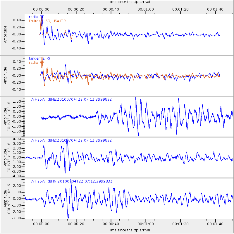
Earthquake location: Near East Coast Of Honshu, Japan
Earthquake latitude/longitude: 39.7/142.4
Earthquake time(UTC): 2010/07/04 (185) 21:55:51 GMT
Earthquake Depth: 27 km
Earthquake Magnitude: 6.4 MB, 6.1 MS, 6.3 MW, 6.2 MW
Earthquake Catalog/Contributor: WHDF/NEIC
Network: TA USArray Transportable Network (new EarthScope stations)
Station: H25A Fruitdale, SD, USA
Lat/Lon: 44.62 N/103.60 W
Elevation: 942 m
Distance: 77.2 deg
Az: 41.97 deg
Baz: 313.738 deg
Ray Param: 0.050426763
Estimated Moho Depth: 34.75 km
Estimated Crust Vp/Vs: 1.60
Assumed Crust Vp: 6.242 km/s
Estimated Crust Vs: 3.901 km/s
Estimated Crust Poisson's Ratio: 0.18
Radial Match: 94.8608 %
Radial Bump: 400
Transverse Match: 90.422455 %
Transverse Bump: 400
SOD ConfigId: 319893
Insert Time: 2011-01-05 00:26:44.753 +0000
GWidth: 2.5
Max Bumps: 400
Tol: 0.001

Signal To Noise

ChannelStoNSTALTA
TA:H25A: :BHZ:20100704T22:07:12.399983Z15.7006491.263499E-68.0474315E-8
TA:H25A: :BHN:20100704T22:07:12.399983Z7.4038846.4328805E-78.6885215E-8
TA:H25A: :BHE:20100704T22:07:12.399983Z3.41715383.4668864E-71.0145538E-7
Arrivals
Ps3.4 SECOND
PpPs14 SECOND
PsPs/PpSs17 SECOND