You are here: Home > Network List > AU - Australian Seismological Centre Stations List
> Station PSAB2 Pilbara Seismic Array Element B2 > Earthquake Result Viewer
PSAB2 Pilbara Seismic Array Element B2 - Earthquake Result Viewer
| Earthquake location: |
South Sandwich Islands Region |
| Earthquake latitude/longitude: |
-58.6/-26.5 |
| Earthquake time(UTC): |
2018/12/11 (345) 02:26:32 GMT |
| Earthquake Depth: |
165 km |
| Earthquake Magnitude: |
7.1 mww |
| Earthquake Catalog/Contributor: |
NEIC PDE/us |
|
| Network: |
AU Australian Seismological Centre |
| Station: |
PSAB2 Pilbara Seismic Array Element B2 |
| Lat/Lon: |
21.55 S/119.86 E |
| Elevation: |
302 m |
|
| Distance: |
95.4 deg |
| Az: |
148.771 deg |
| Baz: |
196.954 deg |
| Ray Param: |
0.040660437 |
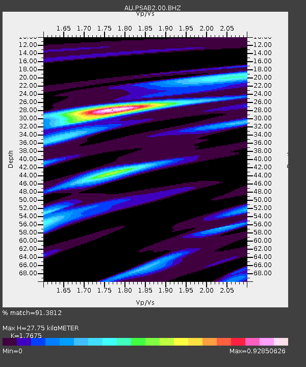
| Estimated Moho Depth: |
27.75 km |
| Estimated Crust Vp/Vs: |
1.77 |
| Assumed Crust Vp: |
6.464 km/s |
| Estimated Crust Vs: |
3.657 km/s |
| Estimated Crust Poisson's Ratio: |
0.26 |
|
| Radial Match: |
91.3812 % |
| Radial Bump: |
400 |
| Transverse Match: |
64.5813 % |
| Transverse Bump: |
400 |
| SOD ConfigId: |
3201911 |
| Insert Time: |
2018-12-25 02:33:48.429 +0000 |
| GWidth: |
2.5 |
| Max Bumps: |
400 |
| Tol: |
0.001 |
|

Signal To Noise
| Channel | StoN | STA | LTA |
| AU:PSAB2:00:BHZ:20181211T02:39:07.068989Z | 2.2221742 | 5.6673065E-7 | 2.550343E-7 |
| AU:PSAB2:00:BH1:20181211T02:39:07.068989Z | 1.5335379 | 2.9530509E-7 | 1.925646E-7 |
| AU:PSAB2:00:BH2:20181211T02:39:07.068989Z | 1.4181542 | 2.3629865E-7 | 1.6662409E-7 |
| Arrivals |
| Ps | 3.4 SECOND |
| PpPs | 12 SECOND |
| PsPs/PpSs | 15 SECOND |


