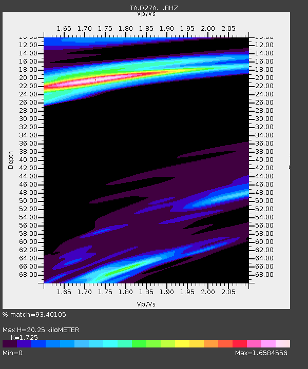
D27A Center, ND, USA - Earthquake Result Viewer

Earthquake location: Near East Coast Of Honshu, Japan
Earthquake latitude/longitude: 39.7/142.4
Earthquake time(UTC): 2010/07/04 (185) 21:55:51 GMT
Earthquake Depth: 27 km
Earthquake Magnitude: 6.4 MB, 6.1 MS, 6.3 MW, 6.2 MW
Earthquake Catalog/Contributor: WHDF/NEIC
Network: TA USArray Transportable Network (new EarthScope stations)
Station: D27A Center, ND, USA
Lat/Lon: 47.11 N/101.53 W
Elevation: 685 m
Distance: 76.5 deg
Az: 39.102 deg
Baz: 314.57 deg
Ray Param: 0.05089107
Estimated Moho Depth: 20.25 km
Estimated Crust Vp/Vs: 1.73
Assumed Crust Vp: 6.438 km/s
Estimated Crust Vs: 3.732 km/s
Estimated Crust Poisson's Ratio: 0.25
Radial Match: 93.40105 %
Radial Bump: 400
Transverse Match: 77.76674 %
Transverse Bump: 400
SOD ConfigId: 319893
Insert Time: 2011-01-05 00:27:09.382 +0000
GWidth: 2.5
Max Bumps: 400
Tol: 0.001

Signal To Noise

ChannelStoNSTALTA
TA:D27A: :BHZ:20100704T22:07:08.50002Z17.1861952.5944312E-61.5096018E-7
TA:D27A: :BHN:20100704T22:07:08.50002Z1.8247455.23086E-72.866625E-7
TA:D27A: :BHE:20100704T22:07:08.50002Z3.01253776.3512755E-72.1082808E-7
Arrivals
Ps2.4 SECOND
PpPs8.3 SECOND
PsPs/PpSs11 SECOND