You are here: Home > Network List > TA - USArray Transportable Network (new EarthScope stations) Stations List
> Station A27A Ledoux Ranch, Antler, ND, USA > Earthquake Result Viewer
A27A Ledoux Ranch, Antler, ND, USA - Earthquake Result Viewer
| Earthquake location: |
Near East Coast Of Honshu, Japan |
| Earthquake latitude/longitude: |
39.7/142.4 |
| Earthquake time(UTC): |
2010/07/04 (185) 21:55:51 GMT |
| Earthquake Depth: |
27 km |
| Earthquake Magnitude: |
6.4 MB, 6.1 MS, 6.3 MW, 6.2 MW |
| Earthquake Catalog/Contributor: |
WHDF/NEIC |
|
| Network: |
TA USArray Transportable Network (new EarthScope stations) |
| Station: |
A27A Ledoux Ranch, Antler, ND, USA |
| Lat/Lon: |
48.95 N/101.24 W |
| Elevation: |
466 m |
|
| Distance: |
75.4 deg |
| Az: |
37.606 deg |
| Baz: |
314.418 deg |
| Ray Param: |
0.05167144 |
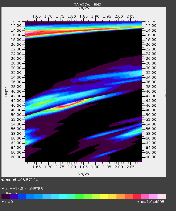
| Estimated Moho Depth: |
14.5 km |
| Estimated Crust Vp/Vs: |
1.60 |
| Assumed Crust Vp: |
6.438 km/s |
| Estimated Crust Vs: |
4.023 km/s |
| Estimated Crust Poisson's Ratio: |
0.18 |
|
| Radial Match: |
95.57124 % |
| Radial Bump: |
286 |
| Transverse Match: |
86.748215 % |
| Transverse Bump: |
400 |
| SOD ConfigId: |
319893 |
| Insert Time: |
2011-01-05 00:28:31.139 +0000 |
| GWidth: |
2.5 |
| Max Bumps: |
400 |
| Tol: |
0.001 |
|
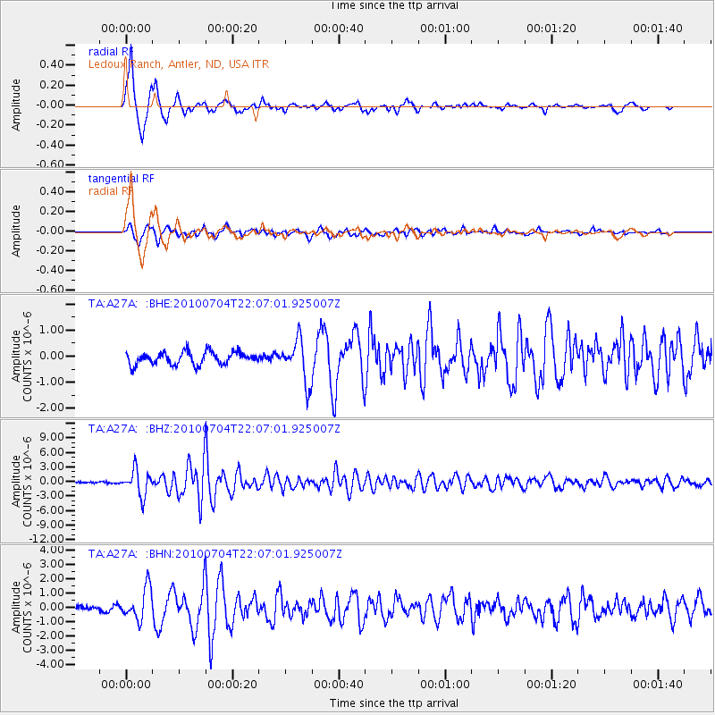
Signal To Noise
| Channel | StoN | STA | LTA |
| TA:A27A: :BHZ:20100704T22:07:01.925007Z | 22.078007 | 2.6219752E-6 | 1.18759594E-7 |
| TA:A27A: :BHN:20100704T22:07:01.925007Z | 6.045337 | 1.1364871E-6 | 1.8799399E-7 |
| TA:A27A: :BHE:20100704T22:07:01.925007Z | 3.4296818 | 8.198231E-7 | 2.3903766E-7 |
| Arrivals |
| Ps | 1.4 SECOND |
| PpPs | 5.6 SECOND |
| PsPs/PpSs | 7.1 SECOND |


