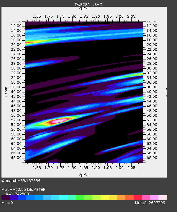
E28A Huff, ND, USA - Earthquake Result Viewer

Earthquake location: Near East Coast Of Honshu, Japan
Earthquake latitude/longitude: 39.7/142.4
Earthquake time(UTC): 2010/07/04 (185) 21:55:51 GMT
Earthquake Depth: 27 km
Earthquake Magnitude: 6.4 MB, 6.1 MS, 6.3 MW, 6.2 MW
Earthquake Catalog/Contributor: WHDF/NEIC
Network: TA USArray Transportable Network (new EarthScope stations)
Station: E28A Huff, ND, USA
Lat/Lon: 46.57 N/100.69 W
Elevation: 579 m
Distance: 77.3 deg
Az: 39.077 deg
Baz: 315.169 deg
Ray Param: 0.050367307
Estimated Moho Depth: 52.25 km
Estimated Crust Vp/Vs: 1.74
Assumed Crust Vp: 6.438 km/s
Estimated Crust Vs: 3.694 km/s
Estimated Crust Poisson's Ratio: 0.25
Radial Match: 89.137886 %
Radial Bump: 400
Transverse Match: 70.63488 %
Transverse Bump: 400
SOD ConfigId: 319893
Insert Time: 2011-01-05 00:28:55.243 +0000
GWidth: 2.5
Max Bumps: 400
Tol: 0.001

Signal To Noise

ChannelStoNSTALTA
TA:E28A: :BHZ:20100704T22:07:12.87502Z12.5194581.5620033E-61.2476605E-7
TA:E28A: :BHN:20100704T22:07:12.87502Z1.27972332.369828E-71.8518286E-7
TA:E28A: :BHE:20100704T22:07:12.87502Z1.93015334.0259064E-72.0857964E-7
Arrivals
Ps6.2 SECOND
PpPs22 SECOND
PsPs/PpSs28 SECOND