You are here: Home > Network List > TA - USArray Transportable Network (new EarthScope stations) Stations List
> Station A30A Hoffart Farm, Langdon, ND, USA > Earthquake Result Viewer
A30A Hoffart Farm, Langdon, ND, USA - Earthquake Result Viewer
| Earthquake location: |
Near East Coast Of Honshu, Japan |
| Earthquake latitude/longitude: |
39.7/142.4 |
| Earthquake time(UTC): |
2010/07/04 (185) 21:55:51 GMT |
| Earthquake Depth: |
27 km |
| Earthquake Magnitude: |
6.4 MB, 6.1 MS, 6.3 MW, 6.2 MW |
| Earthquake Catalog/Contributor: |
WHDF/NEIC |
|
| Network: |
TA USArray Transportable Network (new EarthScope stations) |
| Station: |
A30A Hoffart Farm, Langdon, ND, USA |
| Lat/Lon: |
48.94 N/98.30 W |
| Elevation: |
484 m |
|
| Distance: |
76.8 deg |
| Az: |
36.195 deg |
| Baz: |
316.289 deg |
| Ray Param: |
0.050747793 |
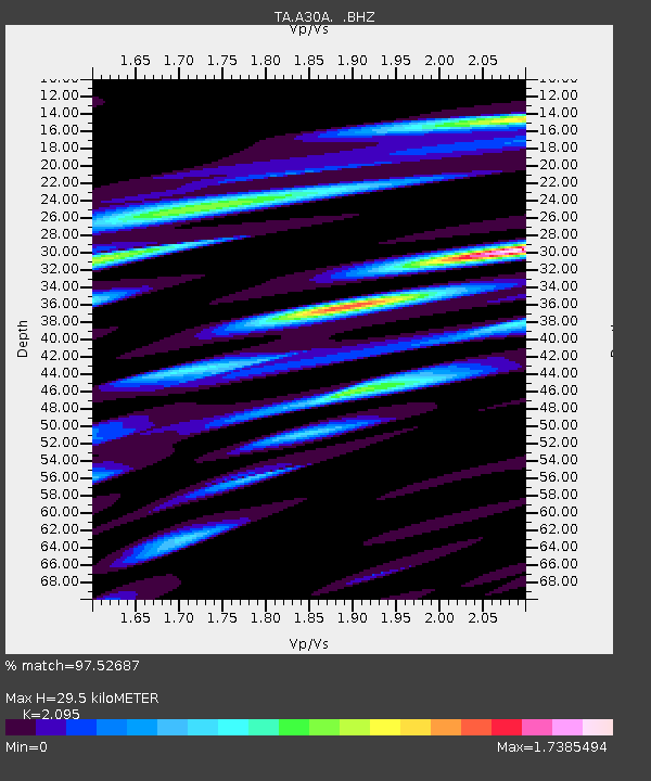
| Estimated Moho Depth: |
29.5 km |
| Estimated Crust Vp/Vs: |
2.10 |
| Assumed Crust Vp: |
6.53 km/s |
| Estimated Crust Vs: |
3.117 km/s |
| Estimated Crust Poisson's Ratio: |
0.35 |
|
| Radial Match: |
97.52687 % |
| Radial Bump: |
283 |
| Transverse Match: |
94.42352 % |
| Transverse Bump: |
400 |
| SOD ConfigId: |
319893 |
| Insert Time: |
2011-01-05 00:29:07.044 +0000 |
| GWidth: |
2.5 |
| Max Bumps: |
400 |
| Tol: |
0.001 |
|

Signal To Noise
| Channel | StoN | STA | LTA |
| TA:A30A: :BHZ:20100704T22:07:09.699971Z | 21.879223 | 1.9237964E-6 | 8.792801E-8 |
| TA:A30A: :BHN:20100704T22:07:09.699971Z | 7.150195 | 1.0943859E-6 | 1.5305679E-7 |
| TA:A30A: :BHE:20100704T22:07:09.699971Z | 8.947111 | 1.2509846E-6 | 1.3981995E-7 |
| Arrivals |
| Ps | 5.1 SECOND |
| PpPs | 14 SECOND |
| PsPs/PpSs | 19 SECOND |


