You are here: Home > Network List > TA - USArray Transportable Network (new EarthScope stations) Stations List
> Station M31A Lambtecht Ranch, Loup City, NE, USA > Earthquake Result Viewer
M31A Lambtecht Ranch, Loup City, NE, USA - Earthquake Result Viewer
| Earthquake location: |
Near East Coast Of Honshu, Japan |
| Earthquake latitude/longitude: |
39.7/142.4 |
| Earthquake time(UTC): |
2010/07/04 (185) 21:55:51 GMT |
| Earthquake Depth: |
27 km |
| Earthquake Magnitude: |
6.4 MB, 6.1 MS, 6.3 MW, 6.2 MW |
| Earthquake Catalog/Contributor: |
WHDF/NEIC |
|
| Network: |
TA USArray Transportable Network (new EarthScope stations) |
| Station: |
M31A Lambtecht Ranch, Loup City, NE, USA |
| Lat/Lon: |
41.34 N/98.98 W |
| Elevation: |
699 m |
|
| Distance: |
81.9 deg |
| Az: |
41.86 deg |
| Baz: |
316.86 deg |
| Ray Param: |
0.04719641 |
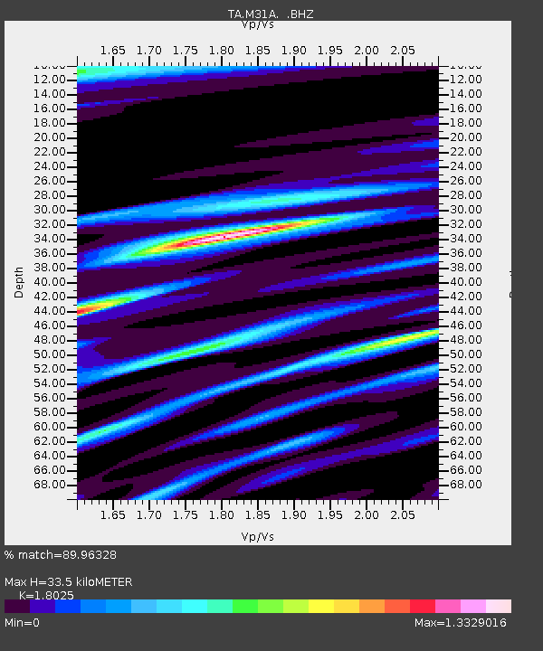
| Estimated Moho Depth: |
33.5 km |
| Estimated Crust Vp/Vs: |
1.80 |
| Assumed Crust Vp: |
6.53 km/s |
| Estimated Crust Vs: |
3.623 km/s |
| Estimated Crust Poisson's Ratio: |
0.28 |
|
| Radial Match: |
89.96328 % |
| Radial Bump: |
363 |
| Transverse Match: |
84.55225 % |
| Transverse Bump: |
400 |
| SOD ConfigId: |
319893 |
| Insert Time: |
2011-01-05 00:29:56.028 +0000 |
| GWidth: |
2.5 |
| Max Bumps: |
400 |
| Tol: |
0.001 |
|
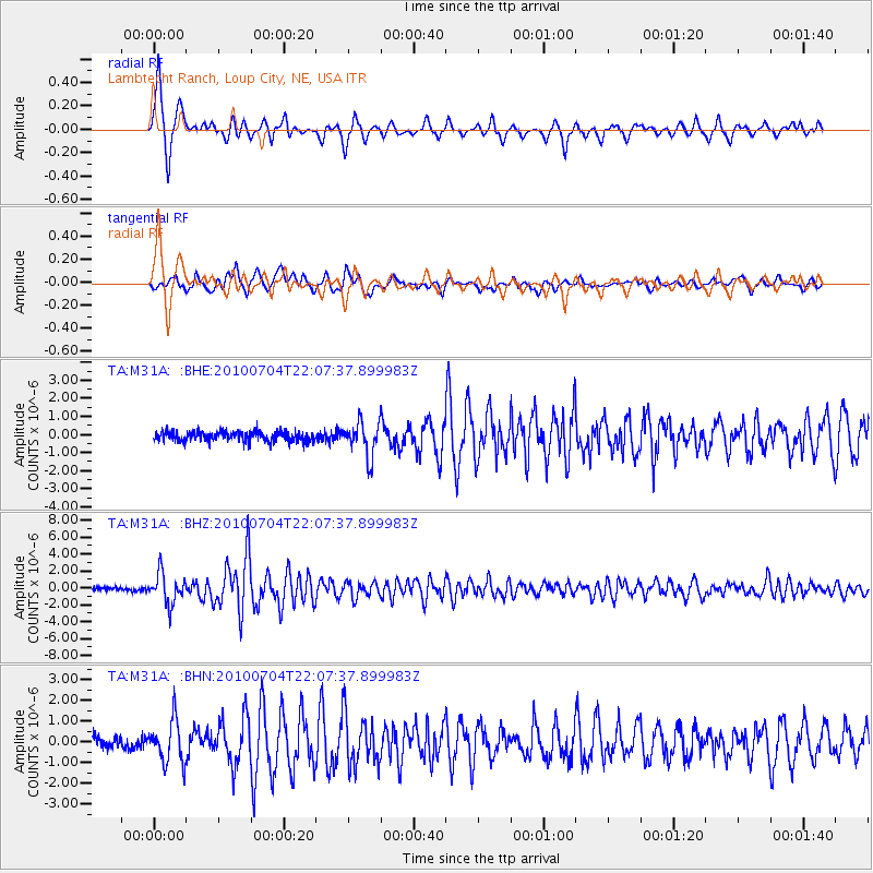
Signal To Noise
| Channel | StoN | STA | LTA |
| TA:M31A: :BHZ:20100704T22:07:37.899983Z | 9.812751 | 1.7782168E-6 | 1.8121493E-7 |
| TA:M31A: :BHN:20100704T22:07:37.899983Z | 3.5766127 | 9.985201E-7 | 2.7918037E-7 |
| TA:M31A: :BHE:20100704T22:07:37.899983Z | 3.4614782 | 9.3521663E-7 | 2.701784E-7 |
| Arrivals |
| Ps | 4.2 SECOND |
| PpPs | 14 SECOND |
| PsPs/PpSs | 18 SECOND |


