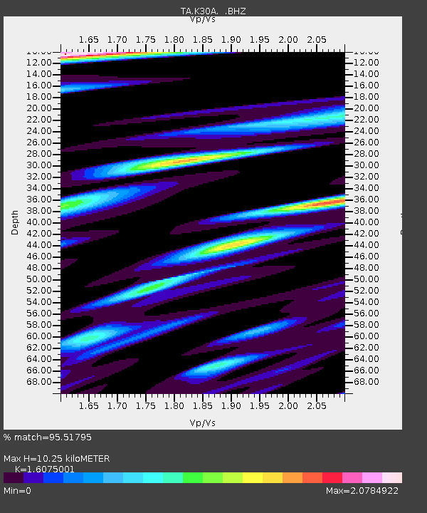
K30A Basset, NE, USA - Earthquake Result Viewer

Earthquake location: Near East Coast Of Honshu, Japan
Earthquake latitude/longitude: 39.7/142.4
Earthquake time(UTC): 2010/07/04 (185) 21:55:51 GMT
Earthquake Depth: 27 km
Earthquake Magnitude: 6.4 MB, 6.1 MS, 6.3 MW, 6.2 MW
Earthquake Catalog/Contributor: WHDF/NEIC
Network: TA USArray Transportable Network (new EarthScope stations)
Station: K30A Basset, NE, USA
Lat/Lon: 42.67 N/99.61 W
Elevation: 712 m
Distance: 80.7 deg
Az: 41.285 deg
Baz: 316.348 deg
Ray Param: 0.048096944
Estimated Moho Depth: 10.25 km
Estimated Crust Vp/Vs: 1.61
Assumed Crust Vp: 6.53 km/s
Estimated Crust Vs: 4.062 km/s
Estimated Crust Poisson's Ratio: 0.18
Radial Match: 95.51795 %
Radial Bump: 369
Transverse Match: 88.78859 %
Transverse Bump: 400
SOD ConfigId: 319893
Insert Time: 2011-01-05 00:30:50.716 +0000
GWidth: 2.5
Max Bumps: 400
Tol: 0.001

Signal To Noise

ChannelStoNSTALTA
TA:K30A: :BHZ:20100704T22:07:31.074971Z19.6250671.6859506E-68.590802E-8
TA:K30A: :BHN:20100704T22:07:31.074971Z9.4173569.569883E-71.0161964E-7
TA:K30A: :BHE:20100704T22:07:31.074971Z4.7433418.3829156E-71.767302E-7
Arrivals
Ps1.0 SECOND
PpPs4.0 SECOND
PsPs/PpSs4.9 SECOND