You are here: Home > Network List > MQ - Martinique Seismic and Volcano Observatory Network Stations List
> Station LAM Morne Lacroix - Martinique > Earthquake Result Viewer
LAM Morne Lacroix - Martinique - Earthquake Result Viewer

| Earthquake location: |
South Sandwich Islands Region |
| Earthquake latitude/longitude: |
-58.6/-26.5 |
| Earthquake time(UTC): |
2018/12/11 (345) 02:26:32 GMT |
| Earthquake Depth: |
165 km |
| Earthquake Magnitude: |
7.1 mww |
| Earthquake Catalog/Contributor: |
NEIC PDE/us |
|
| Network: |
MQ Martinique Seismic and Volcano Observatory Network |
| Station: |
LAM Morne Lacroix - Martinique |
| Lat/Lon: |
14.81 N/61.16 W |
| Elevation: |
1240 m |
|
| Distance: |
78.5 deg |
| Az: |
325.812 deg |
| Baz: |
162.291 deg |
| Ray Param: |
0.049217056 |
| Estimated Moho Depth: |
31.0 km |
| Estimated Crust Vp/Vs: |
1.93 |
| Assumed Crust Vp: |
5.88 km/s |
| Estimated Crust Vs: |
3.047 km/s |
| Estimated Crust Poisson's Ratio: |
0.32 |
|
| Radial Match: |
84.88346 % |
| Radial Bump: |
400 |
| Transverse Match: |
81.71992 % |
| Transverse Bump: |
400 |
| SOD ConfigId: |
3201911 |
| Insert Time: |
2018-12-25 02:35:44.068 +0000 |
| GWidth: |
2.5 |
| Max Bumps: |
400 |
| Tol: |
0.001 |
|
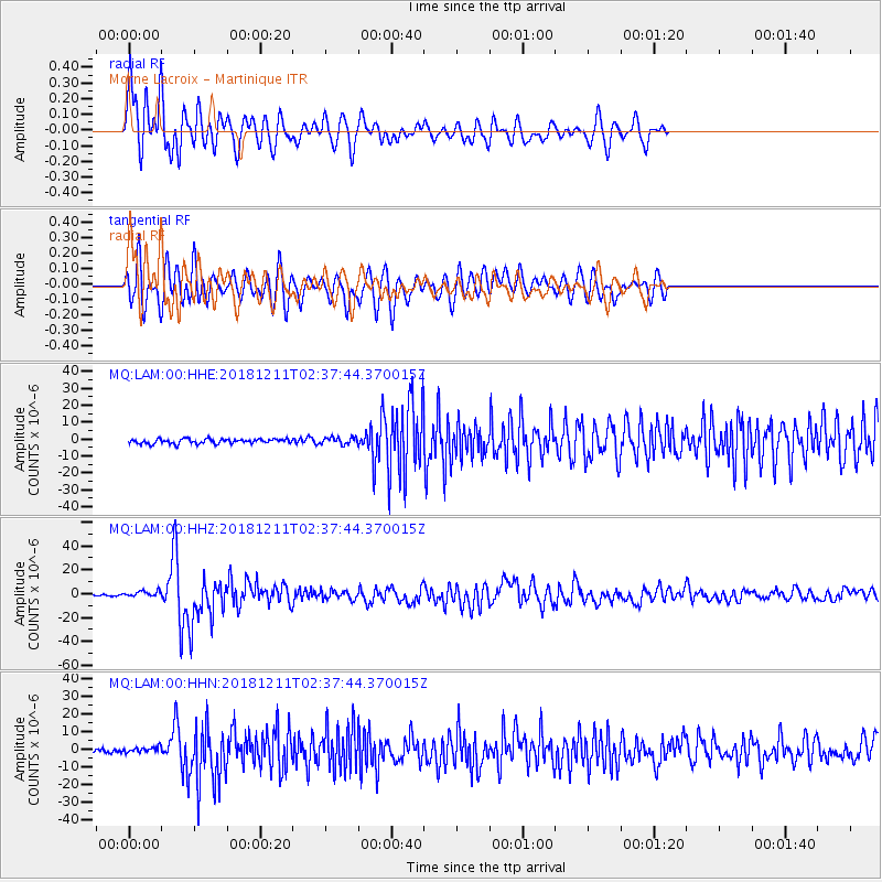
Signal To Noise
| Channel | StoN | STA | LTA |
| MQ:LAM:00:HHZ:20181211T02:37:44.370015Z | 4.6744165 | 2.6646107E-6 | 5.700413E-7 |
| MQ:LAM:00:HHN:20181211T02:37:44.370015Z | 1.1511246 | 1.5093839E-6 | 1.3112254E-6 |
| MQ:LAM:00:HHE:20181211T02:37:44.370015Z | 1.4821539 | 2.0614486E-6 | 1.3908465E-6 |
| Arrivals |
| Ps | 5.0 SECOND |
| PpPs | 15 SECOND |
| PsPs/PpSs | 20 SECOND |


