You are here: Home > Network List > MQ - Martinique Seismic and Volcano Observatory Network Stations List
> Station ZAM Zone Aero-Militaire - Martinique > Earthquake Result Viewer
ZAM Zone Aero-Militaire - Martinique - Earthquake Result Viewer

| Earthquake location: |
South Sandwich Islands Region |
| Earthquake latitude/longitude: |
-58.6/-26.5 |
| Earthquake time(UTC): |
2018/12/11 (345) 02:26:32 GMT |
| Earthquake Depth: |
165 km |
| Earthquake Magnitude: |
7.1 mww |
| Earthquake Catalog/Contributor: |
NEIC PDE/us |
|
| Network: |
MQ Martinique Seismic and Volcano Observatory Network |
| Station: |
ZAM Zone Aero-Militaire - Martinique |
| Lat/Lon: |
14.59 N/61.02 W |
| Elevation: |
11 m |
|
| Distance: |
78.2 deg |
| Az: |
325.874 deg |
| Baz: |
162.339 deg |
| Ray Param: |
0.04938959 |
| Estimated Moho Depth: |
21.25 km |
| Estimated Crust Vp/Vs: |
1.80 |
| Assumed Crust Vp: |
5.88 km/s |
| Estimated Crust Vs: |
3.276 km/s |
| Estimated Crust Poisson's Ratio: |
0.27 |
|
| Radial Match: |
93.353645 % |
| Radial Bump: |
371 |
| Transverse Match: |
85.292694 % |
| Transverse Bump: |
400 |
| SOD ConfigId: |
3201911 |
| Insert Time: |
2018-12-25 02:35:50.602 +0000 |
| GWidth: |
2.5 |
| Max Bumps: |
400 |
| Tol: |
0.001 |
|
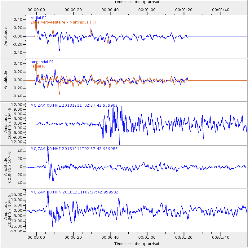
Signal To Noise
| Channel | StoN | STA | LTA |
| MQ:ZAM:00:HHZ:20181211T02:37:42.95998Z | 7.4927034 | 2.3070975E-6 | 3.0791256E-7 |
| MQ:ZAM:00:HHN:20181211T02:37:42.95998Z | 2.9423912 | 1.0168724E-6 | 3.455939E-7 |
| MQ:ZAM:00:HHE:20181211T02:37:42.95998Z | 1.1660742 | 5.1312287E-7 | 4.4004307E-7 |
| Arrivals |
| Ps | 2.9 SECOND |
| PpPs | 9.9 SECOND |
| PsPs/PpSs | 13 SECOND |


