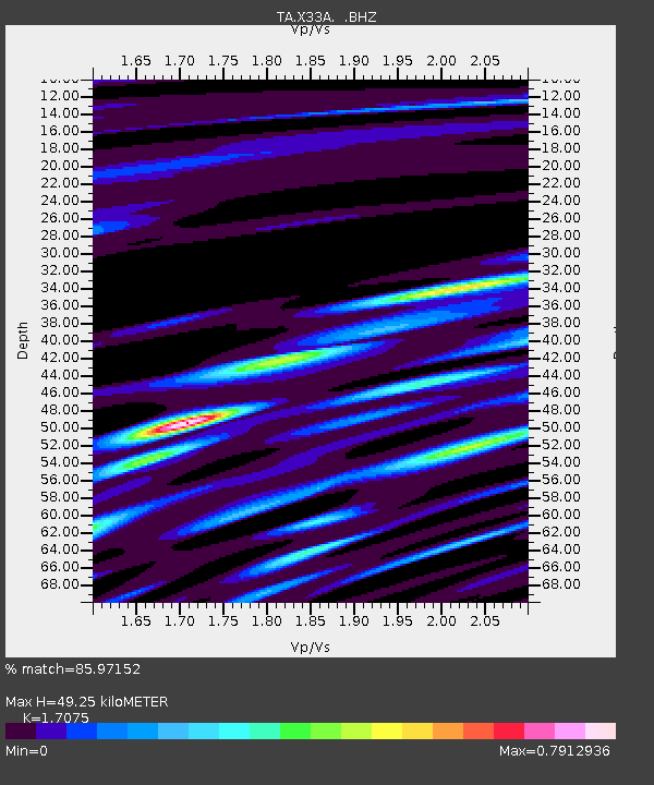
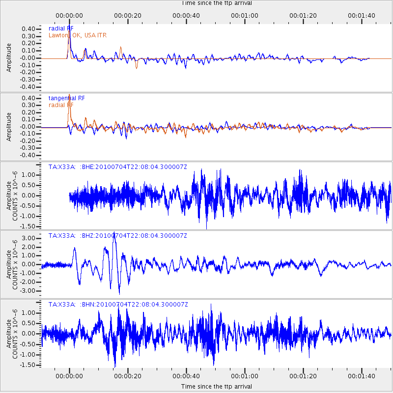
X33A Lawton, OK, USA - Earthquake Result Viewer

Earthquake location: Near East Coast Of Honshu, Japan
Earthquake latitude/longitude: 39.7/142.4
Earthquake time(UTC): 2010/07/04 (185) 21:55:51 GMT
Earthquake Depth: 27 km
Earthquake Magnitude: 6.4 MB, 6.1 MS, 6.3 MW, 6.2 MW
Earthquake Catalog/Contributor: WHDF/NEIC
Network: TA USArray Transportable Network (new EarthScope stations)
Station: X33A Lawton, OK, USA
Lat/Lon: 34.54 N/98.50 W
Elevation: 346 m
Distance: 87.2 deg
Az: 46.216 deg
Baz: 317.565 deg
Ray Param: 0.043471325
Estimated Moho Depth: 49.25 km
Estimated Crust Vp/Vs: 1.71
Assumed Crust Vp: 6.315 km/s
Estimated Crust Vs: 3.699 km/s
Estimated Crust Poisson's Ratio: 0.24
Radial Match: 85.97152 %
Radial Bump: 400
Transverse Match: 79.30995 %
Transverse Bump: 400
SOD ConfigId: 319893
Insert Time: 2011-01-05 00:31:52.910 +0000
GWidth: 2.5
Max Bumps: 400
Tol: 0.001

Signal To Noise

ChannelStoNSTALTA
TA:X33A: :BHZ:20100704T22:08:04.300007Z7.63669731.05506E-61.3815658E-7
TA:X33A: :BHN:20100704T22:08:04.300007Z0.85090532.5014916E-72.9398E-7
TA:X33A: :BHE:20100704T22:08:04.300007Z1.10572793.0626632E-72.769816E-7
Arrivals
Ps5.6 SECOND
PpPs21 SECOND
PsPs/PpSs26 SECOND