You are here: Home > Network List > PF - Volcanologic Network of Piton de Fournaise-OVPF Stations List
> Station CAM College de Cambuston > Earthquake Result Viewer
CAM College de Cambuston - Earthquake Result Viewer
| Earthquake location: |
South Sandwich Islands Region |
| Earthquake latitude/longitude: |
-58.6/-26.5 |
| Earthquake time(UTC): |
2018/12/11 (345) 02:26:32 GMT |
| Earthquake Depth: |
165 km |
| Earthquake Magnitude: |
7.1 mww |
| Earthquake Catalog/Contributor: |
NEIC PDE/us |
|
| Network: |
PF Volcanologic Network of Piton de Fournaise-OVPF |
| Station: |
CAM College de Cambuston |
| Lat/Lon: |
20.93 S/55.65 E |
| Elevation: |
15 m |
|
| Distance: |
68.3 deg |
| Az: |
94.732 deg |
| Baz: |
213.931 deg |
| Ray Param: |
0.055938177 |
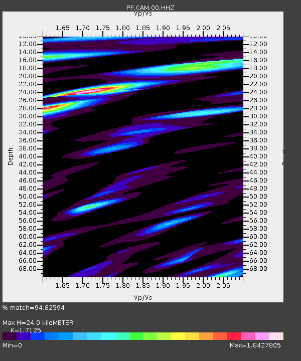
| Estimated Moho Depth: |
24.0 km |
| Estimated Crust Vp/Vs: |
1.71 |
| Assumed Crust Vp: |
4.73 km/s |
| Estimated Crust Vs: |
2.762 km/s |
| Estimated Crust Poisson's Ratio: |
0.24 |
|
| Radial Match: |
94.82594 % |
| Radial Bump: |
375 |
| Transverse Match: |
78.77077 % |
| Transverse Bump: |
400 |
| SOD ConfigId: |
3201911 |
| Insert Time: |
2018-12-25 02:35:52.767 +0000 |
| GWidth: |
2.5 |
| Max Bumps: |
400 |
| Tol: |
0.001 |
|
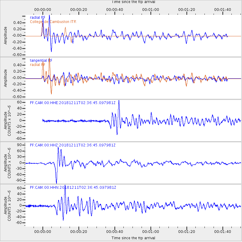
Signal To Noise
| Channel | StoN | STA | LTA |
| PF:CAM:00:HHZ:20181211T02:36:45.097981Z | 2.2599335 | 3.1926272E-6 | 1.4127085E-6 |
| PF:CAM:00:HHN:20181211T02:36:45.097981Z | 0.9354394 | 1.3466164E-6 | 1.4395548E-6 |
| PF:CAM:00:HHE:20181211T02:36:45.097981Z | 1.0719409 | 1.3856616E-6 | 1.292666E-6 |
| Arrivals |
| Ps | 3.7 SECOND |
| PpPs | 13 SECOND |
| PsPs/PpSs | 17 SECOND |


