You are here: Home > Network List > PF - Volcanologic Network of Piton de Fournaise-OVPF Stations List
> Station CIL Cilaos (Pompiers) > Earthquake Result Viewer
CIL Cilaos (Pompiers) - Earthquake Result Viewer
| Earthquake location: |
South Sandwich Islands Region |
| Earthquake latitude/longitude: |
-58.6/-26.5 |
| Earthquake time(UTC): |
2018/12/11 (345) 02:26:32 GMT |
| Earthquake Depth: |
165 km |
| Earthquake Magnitude: |
7.1 mww |
| Earthquake Catalog/Contributor: |
NEIC PDE/us |
|
| Network: |
PF Volcanologic Network of Piton de Fournaise-OVPF |
| Station: |
CIL Cilaos (Pompiers) |
| Lat/Lon: |
21.13 S/55.47 E |
| Elevation: |
1223 m |
|
| Distance: |
68.0 deg |
| Az: |
94.706 deg |
| Baz: |
213.984 deg |
| Ray Param: |
0.05610748 |
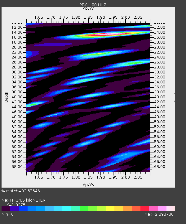
| Estimated Moho Depth: |
14.5 km |
| Estimated Crust Vp/Vs: |
1.93 |
| Assumed Crust Vp: |
4.73 km/s |
| Estimated Crust Vs: |
2.454 km/s |
| Estimated Crust Poisson's Ratio: |
0.32 |
|
| Radial Match: |
92.57546 % |
| Radial Bump: |
400 |
| Transverse Match: |
87.533165 % |
| Transverse Bump: |
400 |
| SOD ConfigId: |
3201911 |
| Insert Time: |
2018-12-25 02:35:53.881 +0000 |
| GWidth: |
2.5 |
| Max Bumps: |
400 |
| Tol: |
0.001 |
|
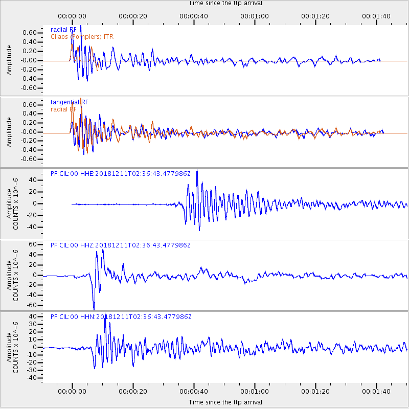
Signal To Noise
| Channel | StoN | STA | LTA |
| PF:CIL:00:HHZ:20181211T02:36:43.477986Z | 5.297014 | 1.7605661E-6 | 3.323695E-7 |
| PF:CIL:00:HHN:20181211T02:36:43.477986Z | 2.1141288 | 1.0153794E-6 | 4.8028267E-7 |
| PF:CIL:00:HHE:20181211T02:36:43.477986Z | 2.6043544 | 9.607413E-7 | 3.6889807E-7 |
| Arrivals |
| Ps | 2.9 SECOND |
| PpPs | 8.8 SECOND |
| PsPs/PpSs | 12 SECOND |


