G03D McMinnville, OR, USA - Earthquake Result Viewer
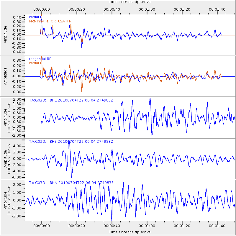
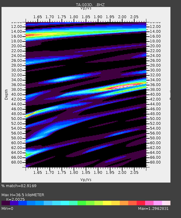
Earthquake location: Near East Coast Of Honshu, Japan
Earthquake latitude/longitude: 39.7/142.4
Earthquake time(UTC): 2010/07/04 (185) 21:55:51 GMT
Earthquake Depth: 27 km
Earthquake Magnitude: 6.4 MB, 6.1 MS, 6.3 MW, 6.2 MW
Earthquake Catalog/Contributor: WHDF/NEIC
Network: TA USArray Transportable Network (new EarthScope stations)
Station: G03D McMinnville, OR, USA
Lat/Lon: 45.21 N/123.26 W
Elevation: 222 m
Distance: 65.9 deg
Az: 50.55 deg
Baz: 302.561 deg
Ray Param: 0.057936277
Estimated Moho Depth: 36.5 km
Estimated Crust Vp/Vs: 2.00
Assumed Crust Vp: 6.566 km/s
Estimated Crust Vs: 3.279 km/s
Estimated Crust Poisson's Ratio: 0.33
Radial Match: 82.9169 %
Radial Bump: 400
Transverse Match: 76.280495 %
Transverse Bump: 400
SOD ConfigId: 319893
Insert Time: 2011-01-05 00:32:05.022 +0000
GWidth: 2.5
Max Bumps: 400
Tol: 0.001

Signal To Noise

ChannelStoNSTALTA
TA:G03D: :BHZ:20100704T22:06:04.274983Z4.99530741.0470612E-62.0960896E-7
TA:G03D: :BHN:20100704T22:06:04.274983Z1.14409763.0906028E-72.7013454E-7
TA:G03D: :BHE:20100704T22:06:04.274983Z2.13021545.3799E-72.5255193E-7
Arrivals
Ps5.8 SECOND
PpPs16 SECOND
PsPs/PpSs22 SECOND