You are here: Home > Network List > PF - Volcanologic Network of Piton de Fournaise-OVPF Stations List
> Station FLR Station Sismologique de Flanc Est > Earthquake Result Viewer
FLR Station Sismologique de Flanc Est - Earthquake Result Viewer
| Earthquake location: |
South Sandwich Islands Region |
| Earthquake latitude/longitude: |
-58.6/-26.5 |
| Earthquake time(UTC): |
2018/12/11 (345) 02:26:32 GMT |
| Earthquake Depth: |
165 km |
| Earthquake Magnitude: |
7.1 mww |
| Earthquake Catalog/Contributor: |
NEIC PDE/us |
|
| Network: |
PF Volcanologic Network of Piton de Fournaise-OVPF |
| Station: |
FLR Station Sismologique de Flanc Est |
| Lat/Lon: |
21.24 S/55.73 E |
| Elevation: |
1947 m |
|
| Distance: |
68.1 deg |
| Az: |
94.99 deg |
| Baz: |
213.996 deg |
| Ray Param: |
0.056075662 |
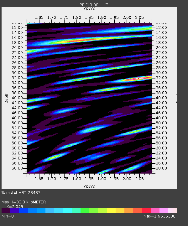
| Estimated Moho Depth: |
32.0 km |
| Estimated Crust Vp/Vs: |
2.05 |
| Assumed Crust Vp: |
4.73 km/s |
| Estimated Crust Vs: |
2.313 km/s |
| Estimated Crust Poisson's Ratio: |
0.34 |
|
| Radial Match: |
82.28437 % |
| Radial Bump: |
400 |
| Transverse Match: |
86.6111 % |
| Transverse Bump: |
400 |
| SOD ConfigId: |
3201911 |
| Insert Time: |
2018-12-25 02:35:58.599 +0000 |
| GWidth: |
2.5 |
| Max Bumps: |
400 |
| Tol: |
0.001 |
|
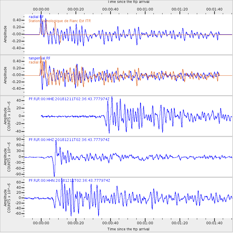
Signal To Noise
| Channel | StoN | STA | LTA |
| PF:FLR:00:HHZ:20181211T02:36:43.777974Z | 3.629034 | 2.494636E-6 | 6.874104E-7 |
| PF:FLR:00:HHN:20181211T02:36:43.777974Z | 1.1492114 | 1.2773999E-6 | 1.1115446E-6 |
| PF:FLR:00:HHE:20181211T02:36:43.777974Z | 1.5897658 | 1.3682362E-6 | 8.606527E-7 |
| Arrivals |
| Ps | 7.2 SECOND |
| PpPs | 20 SECOND |
| PsPs/PpSs | 27 SECOND |


