You are here: Home > Network List > TA - USArray Transportable Network (new EarthScope stations) Stations List
> Station U33A Lingo Farm, Meno, OK, USA > Earthquake Result Viewer
U33A Lingo Farm, Meno, OK, USA - Earthquake Result Viewer
| Earthquake location: |
Near East Coast Of Honshu, Japan |
| Earthquake latitude/longitude: |
39.7/142.4 |
| Earthquake time(UTC): |
2010/07/04 (185) 21:55:51 GMT |
| Earthquake Depth: |
27 km |
| Earthquake Magnitude: |
6.4 MB, 6.1 MS, 6.3 MW, 6.2 MW |
| Earthquake Catalog/Contributor: |
WHDF/NEIC |
|
| Network: |
TA USArray Transportable Network (new EarthScope stations) |
| Station: |
U33A Lingo Farm, Meno, OK, USA |
| Lat/Lon: |
36.43 N/98.11 W |
| Elevation: |
393 m |
|
| Distance: |
86.0 deg |
| Az: |
44.708 deg |
| Baz: |
317.699 deg |
| Ray Param: |
0.044326533 |
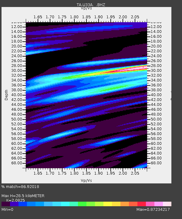
| Estimated Moho Depth: |
28.5 km |
| Estimated Crust Vp/Vs: |
2.08 |
| Assumed Crust Vp: |
6.426 km/s |
| Estimated Crust Vs: |
3.086 km/s |
| Estimated Crust Poisson's Ratio: |
0.35 |
|
| Radial Match: |
86.92018 % |
| Radial Bump: |
400 |
| Transverse Match: |
84.039474 % |
| Transverse Bump: |
400 |
| SOD ConfigId: |
319893 |
| Insert Time: |
2011-01-05 00:32:17.239 +0000 |
| GWidth: |
2.5 |
| Max Bumps: |
400 |
| Tol: |
0.001 |
|
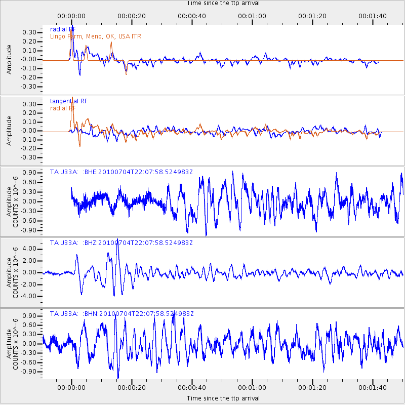
Signal To Noise
| Channel | StoN | STA | LTA |
| TA:U33A: :BHZ:20100704T22:07:58.524983Z | 13.806076 | 1.6299072E-6 | 1.1805723E-7 |
| TA:U33A: :BHN:20100704T22:07:58.524983Z | 2.3109066 | 3.879095E-7 | 1.6786029E-7 |
| TA:U33A: :BHE:20100704T22:07:58.524983Z | 1.7588274 | 2.9555562E-7 | 1.6804128E-7 |
| Arrivals |
| Ps | 4.9 SECOND |
| PpPs | 13 SECOND |
| PsPs/PpSs | 18 SECOND |


