You are here: Home > Network List > PF - Volcanologic Network of Piton de Fournaise-OVPF Stations List
> Station GBS Grandes pentes coulee 1943 bas > Earthquake Result Viewer
GBS Grandes pentes coulee 1943 bas - Earthquake Result Viewer
| Earthquake location: |
South Sandwich Islands Region |
| Earthquake latitude/longitude: |
-58.6/-26.5 |
| Earthquake time(UTC): |
2018/12/11 (345) 02:26:32 GMT |
| Earthquake Depth: |
165 km |
| Earthquake Magnitude: |
7.1 mww |
| Earthquake Catalog/Contributor: |
NEIC PDE/us |
|
| Network: |
PF Volcanologic Network of Piton de Fournaise-OVPF |
| Station: |
GBS Grandes pentes coulee 1943 bas |
| Lat/Lon: |
21.27 S/55.78 E |
| Elevation: |
471 m |
|
| Distance: |
68.1 deg |
| Az: |
95.049 deg |
| Baz: |
214.001 deg |
| Ray Param: |
0.05607767 |
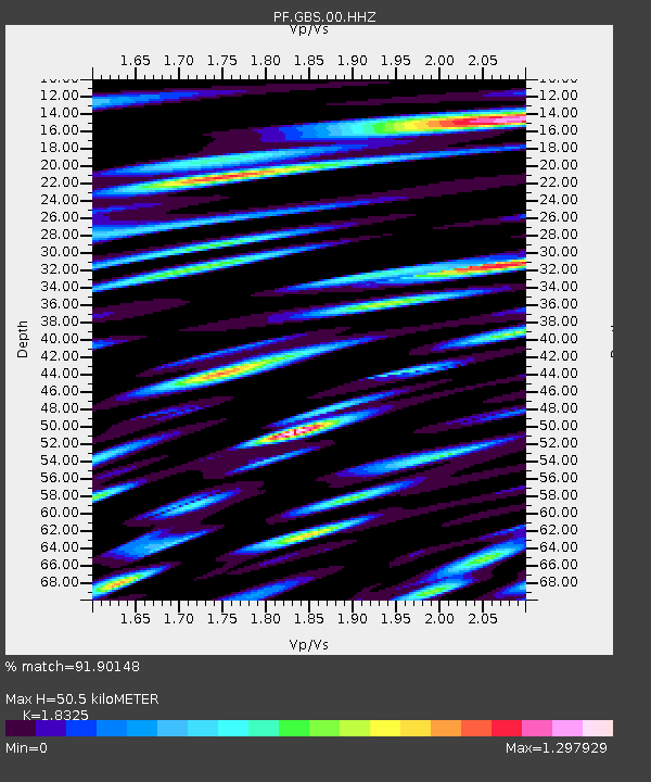
| Estimated Moho Depth: |
50.5 km |
| Estimated Crust Vp/Vs: |
1.83 |
| Assumed Crust Vp: |
4.73 km/s |
| Estimated Crust Vs: |
2.581 km/s |
| Estimated Crust Poisson's Ratio: |
0.29 |
|
| Radial Match: |
91.90148 % |
| Radial Bump: |
400 |
| Transverse Match: |
83.378586 % |
| Transverse Bump: |
400 |
| SOD ConfigId: |
3201911 |
| Insert Time: |
2018-12-25 02:36:03.653 +0000 |
| GWidth: |
2.5 |
| Max Bumps: |
400 |
| Tol: |
0.001 |
|
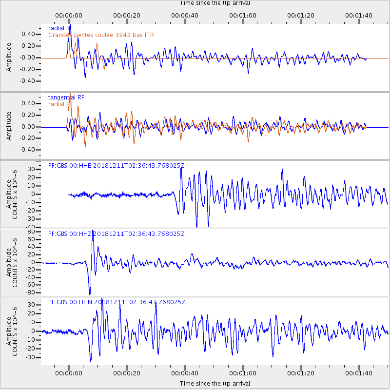
Signal To Noise
| Channel | StoN | STA | LTA |
| PF:GBS:00:HHZ:20181211T02:36:43.768025Z | 2.4961617 | 1.9378542E-6 | 7.7633365E-7 |
| PF:GBS:00:HHN:20181211T02:36:43.768025Z | 0.859856 | 1.4184568E-6 | 1.6496446E-6 |
| PF:GBS:00:HHE:20181211T02:36:43.768025Z | 0.9859891 | 1.2556671E-6 | 1.2735102E-6 |
| Arrivals |
| Ps | 9.1 SECOND |
| PpPs | 30 SECOND |
| PsPs/PpSs | 39 SECOND |


