You are here: Home > Network List > PF - Volcanologic Network of Piton de Fournaise-OVPF Stations List
> Station GPN Grandes Pentes Nord > Earthquake Result Viewer
GPN Grandes Pentes Nord - Earthquake Result Viewer
| Earthquake location: |
South Sandwich Islands Region |
| Earthquake latitude/longitude: |
-58.6/-26.5 |
| Earthquake time(UTC): |
2018/12/11 (345) 02:26:32 GMT |
| Earthquake Depth: |
165 km |
| Earthquake Magnitude: |
7.1 mww |
| Earthquake Catalog/Contributor: |
NEIC PDE/us |
|
| Network: |
PF Volcanologic Network of Piton de Fournaise-OVPF |
| Station: |
GPN Grandes Pentes Nord |
| Lat/Lon: |
21.24 S/55.75 E |
| Elevation: |
1413 m |
|
| Distance: |
68.1 deg |
| Az: |
95.006 deg |
| Baz: |
213.995 deg |
| Ray Param: |
0.05606854 |
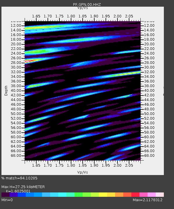
| Estimated Moho Depth: |
27.25 km |
| Estimated Crust Vp/Vs: |
1.60 |
| Assumed Crust Vp: |
4.73 km/s |
| Estimated Crust Vs: |
2.952 km/s |
| Estimated Crust Poisson's Ratio: |
0.18 |
|
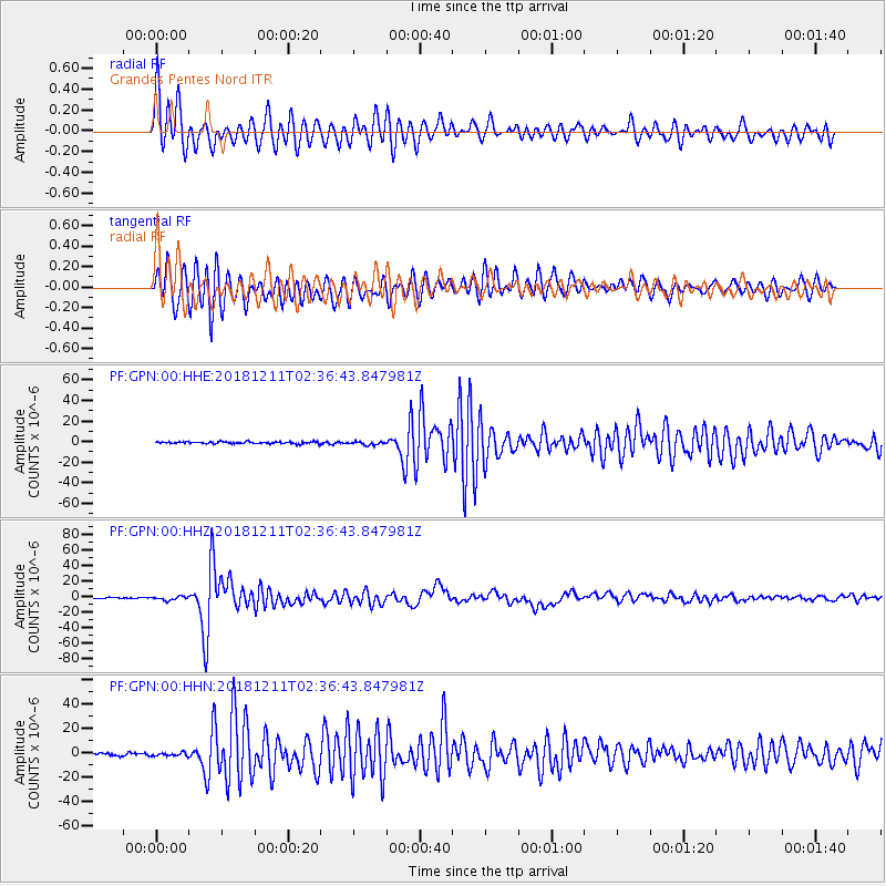
| Radial Match: |
94.10285 % |
| Radial Bump: |
400 |
| Transverse Match: |
91.31763 % |
| Transverse Bump: |
400 |
| SOD ConfigId: |
3201911 |
| Insert Time: |
2018-12-25 02:36:04.965 +0000 |
| GWidth: |
2.5 |
| Max Bumps: |
400 |
| Tol: |
0.001 |
|
Signal To Noise
| Channel | StoN | STA | LTA |
| PF:GPN:00:HHZ:20181211T02:36:43.847981Z | 4.027036 | 2.4388103E-6 | 6.056092E-7 |
| PF:GPN:00:HHN:20181211T02:36:43.847981Z | 1.4111294 | 1.4963481E-6 | 1.0603904E-6 |
| PF:GPN:00:HHE:20181211T02:36:43.847981Z | 1.9024397 | 1.7356863E-6 | 9.1234756E-7 |
| Arrivals |
| Ps | 3.6 SECOND |
| PpPs | 15 SECOND |
| PsPs/PpSs | 18 SECOND |


