You are here: Home > Network List > PQ - Public Safety Geoscience Program Canadian Research Network (PSGP) Stations List
> Station TSIIG Tsiigehtchic, Northwest Territory > Earthquake Result Viewer
TSIIG Tsiigehtchic, Northwest Territory - Earthquake Result Viewer
| Earthquake location: |
Hindu Kush Region, Afghanistan |
| Earthquake latitude/longitude: |
36.5/70.7 |
| Earthquake time(UTC): |
2023/08/05 (217) 16:01:49 GMT |
| Earthquake Depth: |
207 km |
| Earthquake Magnitude: |
5.8 Mww |
| Earthquake Catalog/Contributor: |
NEIC PDE/us |
|
| Network: |
PQ Public Safety Geoscience Program Canadian Research Network (PSGP) |
| Station: |
TSIIG Tsiigehtchic, Northwest Territory |
| Lat/Lon: |
67.44 N/133.74 W |
| Elevation: |
56 m |
|
| Distance: |
74.8 deg |
| Az: |
9.524 deg |
| Baz: |
339.771 deg |
| Ray Param: |
0.051568024 |
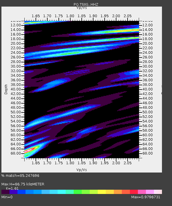
| Estimated Moho Depth: |
66.75 km |
| Estimated Crust Vp/Vs: |
1.61 |
| Assumed Crust Vp: |
6.171 km/s |
| Estimated Crust Vs: |
3.833 km/s |
| Estimated Crust Poisson's Ratio: |
0.19 |
|
| Radial Match: |
85.247696 % |
| Radial Bump: |
400 |
| Transverse Match: |
77.8238 % |
| Transverse Bump: |
400 |
| SOD ConfigId: |
31937991 |
| Insert Time: |
2023-08-19 16:25:10.570 +0000 |
| GWidth: |
2.5 |
| Max Bumps: |
400 |
| Tol: |
0.001 |
|

Signal To Noise
| Channel | StoN | STA | LTA |
| PQ:TSIIG: :HHZ:20230805T16:12:35.799989Z | 54.07161 | 3.2445303E-6 | 6.000432E-8 |
| PQ:TSIIG: :HHN:20230805T16:12:35.799989Z | 13.514825 | 1.1401859E-6 | 8.436557E-8 |
| PQ:TSIIG: :HHE:20230805T16:12:35.799989Z | 5.7676964 | 4.1609283E-7 | 7.214195E-8 |
| Arrivals |
| Ps | 6.8 SECOND |
| PpPs | 27 SECOND |
| PsPs/PpSs | 34 SECOND |


