You are here: Home > Network List > PF - Volcanologic Network of Piton de Fournaise-OVPF Stations List
> Station HDL Station Sismologique de Hubert Delisle > Earthquake Result Viewer
HDL Station Sismologique de Hubert Delisle - Earthquake Result Viewer
| Earthquake location: |
South Sandwich Islands Region |
| Earthquake latitude/longitude: |
-58.6/-26.5 |
| Earthquake time(UTC): |
2018/12/11 (345) 02:26:32 GMT |
| Earthquake Depth: |
165 km |
| Earthquake Magnitude: |
7.1 mww |
| Earthquake Catalog/Contributor: |
NEIC PDE/us |
|
| Network: |
PF Volcanologic Network of Piton de Fournaise-OVPF |
| Station: |
HDL Station Sismologique de Hubert Delisle |
| Lat/Lon: |
21.25 S/55.79 E |
| Elevation: |
242 m |
|
| Distance: |
68.1 deg |
| Az: |
95.044 deg |
| Baz: |
213.995 deg |
| Ray Param: |
0.056061506 |
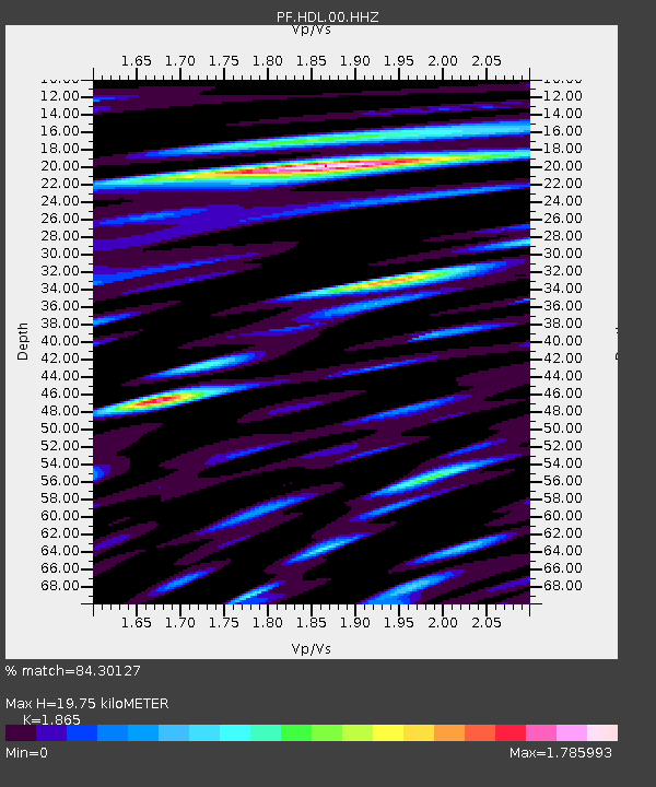
| Estimated Moho Depth: |
19.75 km |
| Estimated Crust Vp/Vs: |
1.87 |
| Assumed Crust Vp: |
4.73 km/s |
| Estimated Crust Vs: |
2.536 km/s |
| Estimated Crust Poisson's Ratio: |
0.30 |
|
| Radial Match: |
84.30127 % |
| Radial Bump: |
350 |
| Transverse Match: |
75.725555 % |
| Transverse Bump: |
385 |
| SOD ConfigId: |
3201911 |
| Insert Time: |
2018-12-25 02:36:07.977 +0000 |
| GWidth: |
2.5 |
| Max Bumps: |
400 |
| Tol: |
0.001 |
|
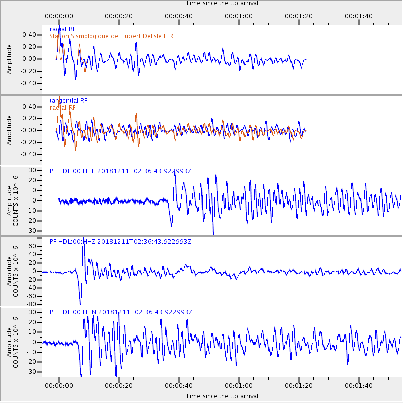
Signal To Noise
| Channel | StoN | STA | LTA |
| PF:HDL:00:HHZ:20181211T02:36:43.922993Z | 2.8507056 | 2.0523241E-6 | 7.199355E-7 |
| PF:HDL:00:HHN:20181211T02:36:43.922993Z | 0.8113295 | 1.0598853E-6 | 1.3063562E-6 |
| PF:HDL:00:HHE:20181211T02:36:43.922993Z | 1.2957561 | 1.7141061E-6 | 1.3228617E-6 |
| Arrivals |
| Ps | 3.7 SECOND |
| PpPs | 12 SECOND |
| PsPs/PpSs | 15 SECOND |


