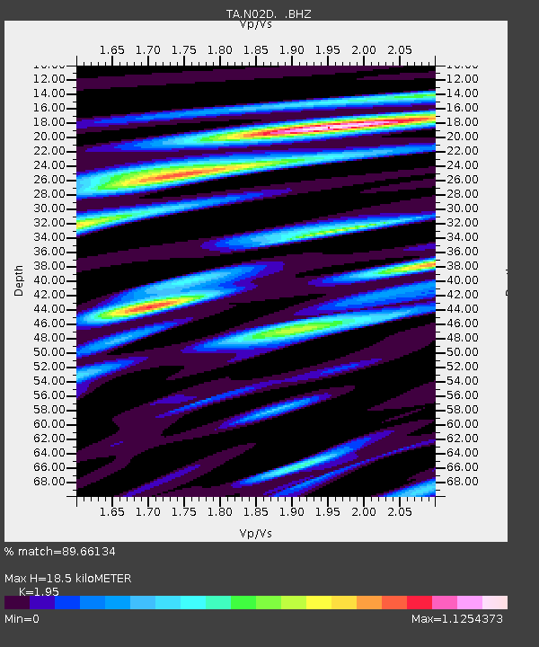
N02D Trinity Center, CA, USA - Earthquake Result Viewer

Earthquake location: Near East Coast Of Honshu, Japan
Earthquake latitude/longitude: 39.7/142.4
Earthquake time(UTC): 2010/07/04 (185) 21:55:51 GMT
Earthquake Depth: 27 km
Earthquake Magnitude: 6.4 MB, 6.1 MS, 6.3 MW, 6.2 MW
Earthquake Catalog/Contributor: WHDF/NEIC
Network: TA USArray Transportable Network (new EarthScope stations)
Station: N02D Trinity Center, CA, USA
Lat/Lon: 40.97 N/122.71 W
Elevation: 937 m
Distance: 68.6 deg
Az: 54.137 deg
Baz: 304.332 deg
Ray Param: 0.056182027
Estimated Moho Depth: 18.5 km
Estimated Crust Vp/Vs: 1.95
Assumed Crust Vp: 6.566 km/s
Estimated Crust Vs: 3.367 km/s
Estimated Crust Poisson's Ratio: 0.32
Radial Match: 89.66134 %
Radial Bump: 400
Transverse Match: 85.47508 %
Transverse Bump: 400
SOD ConfigId: 319893
Insert Time: 2011-01-05 00:33:06.466 +0000
GWidth: 2.5
Max Bumps: 400
Tol: 0.001

Signal To Noise

ChannelStoNSTALTA
TA:N02D: :BHZ:20100704T22:06:21.199971Z4.43080477.6262E-71.7211772E-7
TA:N02D: :BHN:20100704T22:06:21.199971Z1.0004852.05371E-72.0527143E-7
TA:N02D: :BHE:20100704T22:06:21.199971Z2.31601553.739299E-71.6145397E-7
Arrivals
Ps2.8 SECOND
PpPs8.0 SECOND
PsPs/PpSs11 SECOND