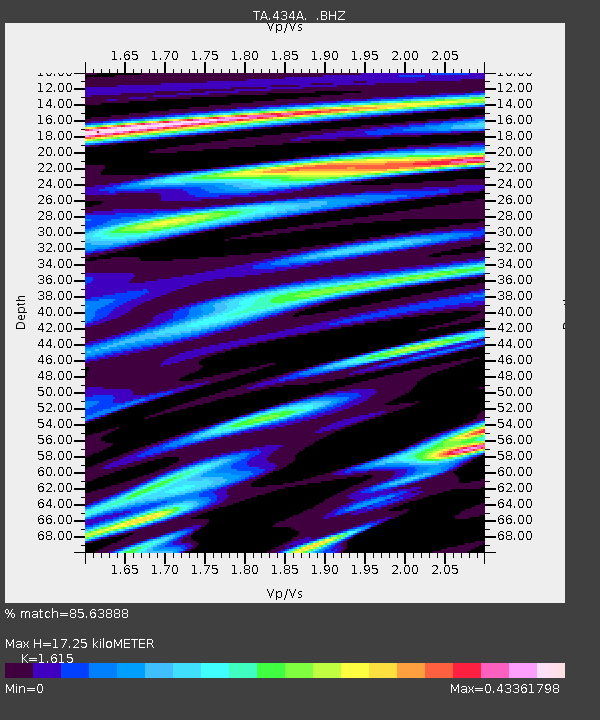
434A Burnet, TX, USA - Earthquake Result Viewer
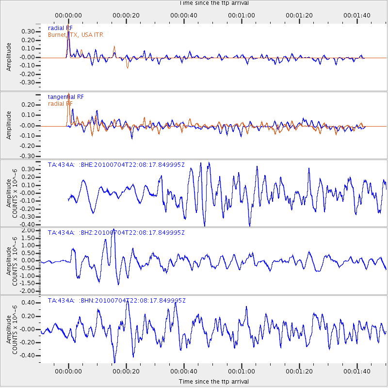
Earthquake location: Near East Coast Of Honshu, Japan
Earthquake latitude/longitude: 39.7/142.4
Earthquake time(UTC): 2010/07/04 (185) 21:55:51 GMT
Earthquake Depth: 27 km
Earthquake Magnitude: 6.4 MB, 6.1 MS, 6.3 MW, 6.2 MW
Earthquake Catalog/Contributor: WHDF/NEIC
Network: TA USArray Transportable Network (new EarthScope stations)
Station: 434A Burnet, TX, USA
Lat/Lon: 30.81 N/98.27 W
Elevation: 462 m
Distance: 90.1 deg
Az: 48.575 deg
Baz: 317.746 deg
Ray Param: 0.041696854
Estimated Moho Depth: 17.25 km
Estimated Crust Vp/Vs: 1.62
Assumed Crust Vp: 6.498 km/s
Estimated Crust Vs: 4.023 km/s
Estimated Crust Poisson's Ratio: 0.19
Radial Match: 85.63888 %
Radial Bump: 400
Transverse Match: 82.75955 %
Transverse Bump: 400
SOD ConfigId: 319893
Insert Time: 2011-01-05 00:33:33.620 +0000
GWidth: 2.5
Max Bumps: 400
Tol: 0.001

Signal To Noise

ChannelStoNSTALTA
TA:434A: :BHZ:20100704T22:08:17.849995Z7.5974116.1890864E-78.14631E-8
TA:434A: :BHN:20100704T22:08:17.849995Z2.77545761.1246621E-74.052168E-8
TA:434A: :BHE:20100704T22:08:17.849995Z1.38310441.2187031E-78.8113595E-8
Arrivals
Ps1.7 SECOND
PpPs6.8 SECOND
PsPs/PpSs8.5 SECOND