You are here: Home > Network List > WI - West Indies IPGP Network Stations List
> Station BIM Morne Bigot, Anses d'Arlets, Martinique > Earthquake Result Viewer
BIM Morne Bigot, Anses d'Arlets, Martinique - Earthquake Result Viewer
| Earthquake location: |
South Sandwich Islands Region |
| Earthquake latitude/longitude: |
-58.6/-26.5 |
| Earthquake time(UTC): |
2018/12/11 (345) 02:26:32 GMT |
| Earthquake Depth: |
165 km |
| Earthquake Magnitude: |
7.1 mww |
| Earthquake Catalog/Contributor: |
NEIC PDE/us |
|
| Network: |
WI West Indies IPGP Network |
| Station: |
BIM Morne Bigot, Anses d'Arlets, Martinique |
| Lat/Lon: |
14.52 N/61.07 W |
| Elevation: |
391 m |
|
| Distance: |
78.2 deg |
| Az: |
325.813 deg |
| Baz: |
162.315 deg |
| Ray Param: |
0.049423505 |
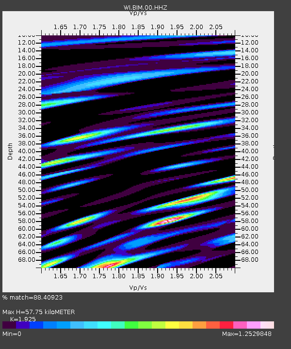
| Estimated Moho Depth: |
57.75 km |
| Estimated Crust Vp/Vs: |
1.92 |
| Assumed Crust Vp: |
5.88 km/s |
| Estimated Crust Vs: |
3.055 km/s |
| Estimated Crust Poisson's Ratio: |
0.32 |
|
| Radial Match: |
88.40923 % |
| Radial Bump: |
400 |
| Transverse Match: |
79.33286 % |
| Transverse Bump: |
400 |
| SOD ConfigId: |
3201911 |
| Insert Time: |
2018-12-25 02:36:25.294 +0000 |
| GWidth: |
2.5 |
| Max Bumps: |
400 |
| Tol: |
0.001 |
|

Signal To Noise
| Channel | StoN | STA | LTA |
| WI:BIM:00:HHZ:20181211T02:37:42.680012Z | 5.143262 | 2.5869524E-6 | 5.0297893E-7 |
| WI:BIM:00:HHN:20181211T02:37:42.680012Z | 1.9923353 | 1.2725599E-6 | 6.387278E-7 |
| WI:BIM:00:HHE:20181211T02:37:42.680012Z | 1.4809362 | 9.191844E-7 | 6.2067795E-7 |
| Arrivals |
| Ps | 9.3 SECOND |
| PpPs | 28 SECOND |
| PsPs/PpSs | 37 SECOND |


