You are here: Home > Network List > WI - West Indies IPGP Network Stations List
> Station CBE Capesterre Belles-Eaux, Guadeloupe > Earthquake Result Viewer
CBE Capesterre Belles-Eaux, Guadeloupe - Earthquake Result Viewer
| Earthquake location: |
South Sandwich Islands Region |
| Earthquake latitude/longitude: |
-58.6/-26.5 |
| Earthquake time(UTC): |
2018/12/11 (345) 02:26:32 GMT |
| Earthquake Depth: |
165 km |
| Earthquake Magnitude: |
7.1 mww |
| Earthquake Catalog/Contributor: |
NEIC PDE/us |
|
| Network: |
WI West Indies IPGP Network |
| Station: |
CBE Capesterre Belles-Eaux, Guadeloupe |
| Lat/Lon: |
16.07 N/61.61 W |
| Elevation: |
380 m |
|
| Distance: |
79.8 deg |
| Az: |
325.781 deg |
| Baz: |
162.166 deg |
| Ray Param: |
0.048322447 |
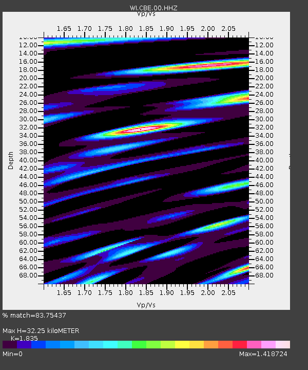
| Estimated Moho Depth: |
32.25 km |
| Estimated Crust Vp/Vs: |
1.84 |
| Assumed Crust Vp: |
6.048 km/s |
| Estimated Crust Vs: |
3.296 km/s |
| Estimated Crust Poisson's Ratio: |
0.29 |
|
| Radial Match: |
83.75437 % |
| Radial Bump: |
400 |
| Transverse Match: |
85.687454 % |
| Transverse Bump: |
400 |
| SOD ConfigId: |
3201911 |
| Insert Time: |
2018-12-25 02:36:27.618 +0000 |
| GWidth: |
2.5 |
| Max Bumps: |
400 |
| Tol: |
0.001 |
|
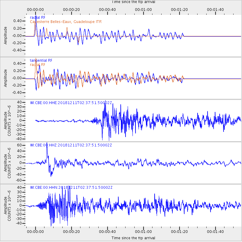
Signal To Noise
| Channel | StoN | STA | LTA |
| WI:CBE:00:HHZ:20181211T02:37:51.50002Z | 4.9248567 | 3.065691E-6 | 6.224935E-7 |
| WI:CBE:00:HHN:20181211T02:37:51.50002Z | 3.370021 | 3.6457102E-6 | 1.0818063E-6 |
| WI:CBE:00:HHE:20181211T02:37:51.50002Z | 2.9106078 | 2.8224265E-6 | 9.697035E-7 |
| Arrivals |
| Ps | 4.6 SECOND |
| PpPs | 15 SECOND |
| PsPs/PpSs | 19 SECOND |


