You are here: Home > Network List > WI - West Indies IPGP Network Stations List
> Station DHS Morne Mazeau - Deshaies, Guadeloupe > Earthquake Result Viewer
DHS Morne Mazeau - Deshaies, Guadeloupe - Earthquake Result Viewer
| Earthquake location: |
South Sandwich Islands Region |
| Earthquake latitude/longitude: |
-58.6/-26.5 |
| Earthquake time(UTC): |
2018/12/11 (345) 02:26:32 GMT |
| Earthquake Depth: |
165 km |
| Earthquake Magnitude: |
7.1 mww |
| Earthquake Catalog/Contributor: |
NEIC PDE/us |
|
| Network: |
WI West Indies IPGP Network |
| Station: |
DHS Morne Mazeau - Deshaies, Guadeloupe |
| Lat/Lon: |
16.27 N/61.77 W |
| Elevation: |
618 m |
|
| Distance: |
80.0 deg |
| Az: |
325.701 deg |
| Baz: |
162.11 deg |
| Ray Param: |
0.048160363 |
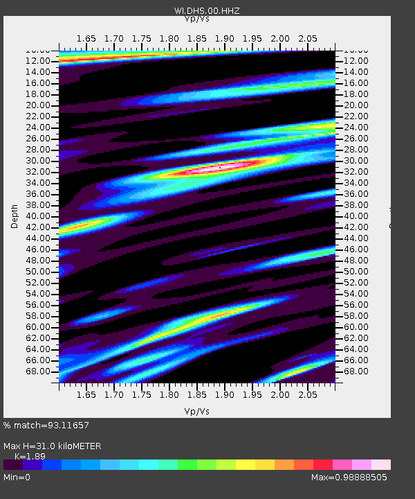
| Estimated Moho Depth: |
31.0 km |
| Estimated Crust Vp/Vs: |
1.89 |
| Assumed Crust Vp: |
6.048 km/s |
| Estimated Crust Vs: |
3.2 km/s |
| Estimated Crust Poisson's Ratio: |
0.31 |
|
| Radial Match: |
93.11657 % |
| Radial Bump: |
339 |
| Transverse Match: |
76.94887 % |
| Transverse Bump: |
400 |
| SOD ConfigId: |
3201911 |
| Insert Time: |
2018-12-25 02:36:28.557 +0000 |
| GWidth: |
2.5 |
| Max Bumps: |
400 |
| Tol: |
0.001 |
|

Signal To Noise
| Channel | StoN | STA | LTA |
| WI:DHS:00:HHZ:20181211T02:37:52.870015Z | 8.288584 | 3.7974205E-6 | 4.5815074E-7 |
| WI:DHS:00:HHN:20181211T02:37:52.870015Z | 5.946878 | 2.9534212E-6 | 4.966339E-7 |
| WI:DHS:00:HHE:20181211T02:37:52.870015Z | 8.902507 | 5.7917655E-6 | 6.5057696E-7 |
| Arrivals |
| Ps | 4.7 SECOND |
| PpPs | 14 SECOND |
| PsPs/PpSs | 19 SECOND |


