You are here: Home > Network List > IU - Global Seismograph Network (GSN - IRIS/USGS) Stations List
> Station CTAO Charters Towers, Australia > Earthquake Result Viewer
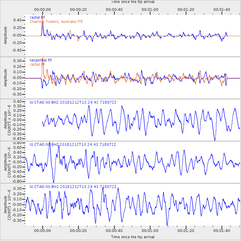
CTAO Charters Towers, Australia - Earthquake Result Viewer
*The percent match for this event was below the threshold and hence no stack was calculated.
| Earthquake location: |
Pacific-Antarctic Ridge |
| Earthquake latitude/longitude: |
-55.8/-128.5 |
| Earthquake time(UTC): |
2018/12/12 (346) 13:13:57 GMT |
| Earthquake Depth: |
10 km |
| Earthquake Magnitude: |
6.3 Mww |
| Earthquake Catalog/Contributor: |
NEIC PDE/us |
|
| Network: |
IU Global Seismograph Network (GSN - IRIS/USGS) |
| Station: |
CTAO Charters Towers, Australia |
| Lat/Lon: |
20.09 S/146.25 E |
| Elevation: |
357 m |
|
| Distance: |
71.0 deg |
| Az: |
262.17 deg |
| Baz: |
143.474 deg |
| Ray Param: |
$rayparam |
*The percent match for this event was below the threshold and hence was not used in the summary stack. |
|
| Radial Match: |
56.487957 % |
| Radial Bump: |
362 |
| Transverse Match: |
54.621685 % |
| Transverse Bump: |
400 |
| SOD ConfigId: |
3201911 |
| Insert Time: |
2018-12-26 13:18:00.827 +0000 |
| GWidth: |
2.5 |
| Max Bumps: |
400 |
| Tol: |
0.001 |
|
Signal To Noise
| Channel | StoN | STA | LTA |
| IU:CTAO:00:BHZ:20181212T13:24:43.718972Z | 2.2502675 | 3.610495E-7 | 1.6044737E-7 |
| IU:CTAO:00:BH1:20181212T13:24:43.718972Z | 1.3598565 | 1.512161E-7 | 1.11200045E-7 |
| IU:CTAO:00:BH2:20181212T13:24:43.718972Z | 2.3785565 | 1.7135572E-7 | 7.204189E-8 |
| Arrivals |
| Ps | |
| PpPs | |
| PsPs/PpSs | |


