You are here: Home > Network List > TA - USArray Transportable Network (new EarthScope stations) Stations List
> Station 339A Huntington, TX, USA > Earthquake Result Viewer
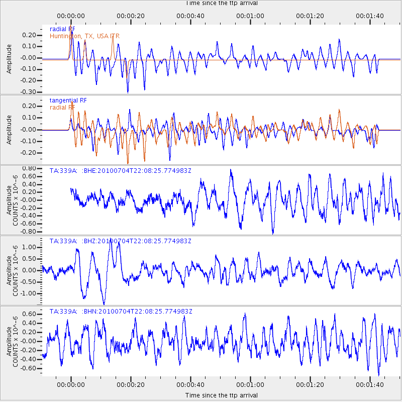
339A Huntington, TX, USA - Earthquake Result Viewer
*The percent match for this event was below the threshold and hence no stack was calculated.
| Earthquake location: |
Near East Coast Of Honshu, Japan |
| Earthquake latitude/longitude: |
39.7/142.4 |
| Earthquake time(UTC): |
2010/07/04 (185) 21:55:51 GMT |
| Earthquake Depth: |
27 km |
| Earthquake Magnitude: |
6.4 MB, 6.1 MS, 6.3 MW, 6.2 MW |
| Earthquake Catalog/Contributor: |
WHDF/NEIC |
|
| Network: |
TA USArray Transportable Network (new EarthScope stations) |
| Station: |
339A Huntington, TX, USA |
| Lat/Lon: |
31.33 N/94.56 W |
| Elevation: |
82 m |
|
| Distance: |
91.8 deg |
| Az: |
45.839 deg |
| Baz: |
319.697 deg |
| Ray Param: |
$rayparam |
*The percent match for this event was below the threshold and hence was not used in the summary stack. |
|
| Radial Match: |
72.98705 % |
| Radial Bump: |
400 |
| Transverse Match: |
61.241688 % |
| Transverse Bump: |
400 |
| SOD ConfigId: |
319893 |
| Insert Time: |
2011-01-05 00:36:25.071 +0000 |
| GWidth: |
2.5 |
| Max Bumps: |
400 |
| Tol: |
0.001 |
|
Signal To Noise
| Channel | StoN | STA | LTA |
| TA:339A: :BHZ:20100704T22:08:25.774983Z | 6.3034034 | 6.7968415E-7 | 1.0782812E-7 |
| TA:339A: :BHN:20100704T22:08:25.774983Z | 1.1041316 | 2.0136572E-7 | 1.8237475E-7 |
| TA:339A: :BHE:20100704T22:08:25.774983Z | 1.1723953 | 1.6821245E-7 | 1.4347758E-7 |
| Arrivals |
| Ps | |
| PpPs | |
| PsPs/PpSs | |


